I27A Quinn, SD, USA - Earthquake Result Viewer
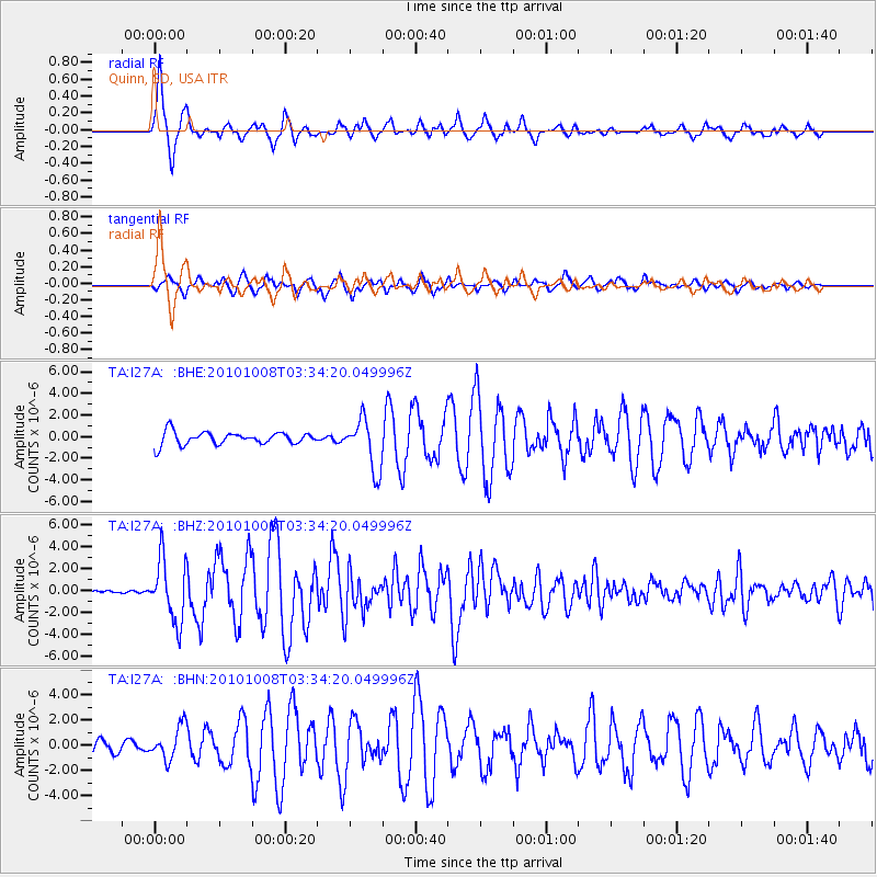
Earthquake location: Andreanof Islands, Aleutian Is.
Earthquake latitude/longitude: 51.4/-175.4
Earthquake time(UTC): 2010/10/08 (281) 03:26:13 GMT
Earthquake Depth: 19 km
Earthquake Magnitude: 6.2 MB, 6.3 MS, 6.4 MW, 6.2 MW
Earthquake Catalog/Contributor: WHDF/NEIC
Network: TA USArray Transportable Network (new EarthScope stations)
Station: I27A Quinn, SD, USA
Lat/Lon: 44.07 N/102.05 W
Elevation: 867 m
Distance: 47.9 deg
Az: 68.419 deg
Baz: 306.043 deg
Ray Param: 0.069647335
Estimated Moho Depth: 40.25 km
Estimated Crust Vp/Vs: 1.74
Assumed Crust Vp: 6.242 km/s
Estimated Crust Vs: 3.593 km/s
Estimated Crust Poisson's Ratio: 0.25
Radial Match: 93.14758 %
Radial Bump: 400
Transverse Match: 88.51711 %
Transverse Bump: 400
SOD ConfigId: 339645
Insert Time: 2011-02-10 08:01:07.408 +0000
GWidth: 2.5
Max Bumps: 400
Tol: 0.001

Signal To Noise

ChannelStoNSTALTA
TA:I27A: :BHZ:20101008T03:34:20.049996Z10.3419862.791016E-62.6987237E-7
TA:I27A: :BHN:20101008T03:34:20.049996Z2.61279031.2839489E-64.914091E-7
TA:I27A: :BHE:20101008T03:34:20.049996Z4.0043752.3414323E-65.847186E-7
Arrivals
Ps5.0 SECOND
PpPs17 SECOND
PsPs/PpSs22 SECOND