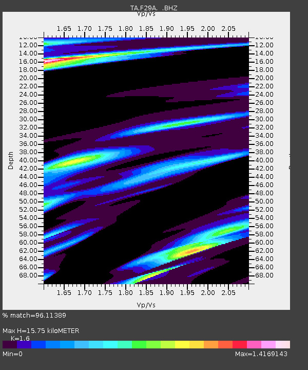
F29A Eureka, SD, USA - Earthquake Result Viewer

Earthquake location: Andreanof Islands, Aleutian Is.
Earthquake latitude/longitude: 51.4/-175.4
Earthquake time(UTC): 2010/10/08 (281) 03:26:13 GMT
Earthquake Depth: 19 km
Earthquake Magnitude: 6.2 MB, 6.3 MS, 6.4 MW, 6.2 MW
Earthquake Catalog/Contributor: WHDF/NEIC
Network: TA USArray Transportable Network (new EarthScope stations)
Station: F29A Eureka, SD, USA
Lat/Lon: 45.83 N/99.83 W
Elevation: 575 m
Distance: 48.2 deg
Az: 65.253 deg
Baz: 305.494 deg
Ray Param: 0.06949133
Estimated Moho Depth: 15.75 km
Estimated Crust Vp/Vs: 1.60
Assumed Crust Vp: 6.53 km/s
Estimated Crust Vs: 4.082 km/s
Estimated Crust Poisson's Ratio: 0.18
Radial Match: 96.11389 %
Radial Bump: 321
Transverse Match: 85.379234 %
Transverse Bump: 375
SOD ConfigId: 339645
Insert Time: 2011-02-10 08:03:56.360 +0000
GWidth: 2.5
Max Bumps: 400
Tol: 0.001

Signal To Noise

ChannelStoNSTALTA
TA:F29A: :BHZ:20101008T03:34:22.000009Z27.7929133.6627464E-61.3178706E-7
TA:F29A: :BHN:20101008T03:34:22.000009Z3.07409242.1905284E-67.125773E-7
TA:F29A: :BHE:20101008T03:34:22.000009Z6.98243333.9101205E-65.5999396E-7
Arrivals
Ps1.6 SECOND
PpPs5.8 SECOND
PsPs/PpSs7.4 SECOND