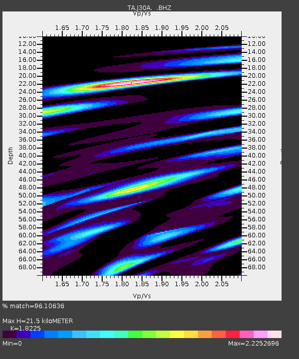
J30A Dallas, SD, USA - Earthquake Result Viewer

Earthquake location: Andreanof Islands, Aleutian Is.
Earthquake latitude/longitude: 51.4/-175.4
Earthquake time(UTC): 2010/10/08 (281) 03:26:13 GMT
Earthquake Depth: 19 km
Earthquake Magnitude: 6.2 MB, 6.3 MS, 6.4 MW, 6.2 MW
Earthquake Catalog/Contributor: WHDF/NEIC
Network: TA USArray Transportable Network (new EarthScope stations)
Station: J30A Dallas, SD, USA
Lat/Lon: 43.32 N/99.49 W
Elevation: 608 m
Distance: 49.9 deg
Az: 67.737 deg
Baz: 307.358 deg
Ray Param: 0.06839739
Estimated Moho Depth: 21.5 km
Estimated Crust Vp/Vs: 1.82
Assumed Crust Vp: 6.53 km/s
Estimated Crust Vs: 3.583 km/s
Estimated Crust Poisson's Ratio: 0.28
Radial Match: 96.10636 %
Radial Bump: 400
Transverse Match: 86.68627 %
Transverse Bump: 400
SOD ConfigId: 339645
Insert Time: 2011-02-10 08:05:03.854 +0000
GWidth: 2.5
Max Bumps: 400
Tol: 0.001

Signal To Noise

ChannelStoNSTALTA
TA:J30A: :BHZ:20101008T03:34:34.875009Z21.243483.2020052E-61.5072884E-7
TA:J30A: :BHN:20101008T03:34:34.875009Z4.5390981.4536697E-63.2025523E-7
TA:J30A: :BHE:20101008T03:34:34.875009Z8.3875722.1886938E-62.6094483E-7
Arrivals
Ps2.9 SECOND
PpPs8.8 SECOND
PsPs/PpSs12 SECOND