You are here: Home > Network List > TA - USArray Transportable Network (new EarthScope stations) Stations List
> Station S32A Newby Ranch, Pratt, KS, USA > Earthquake Result Viewer
S32A Newby Ranch, Pratt, KS, USA - Earthquake Result Viewer
| Earthquake location: |
Andreanof Islands, Aleutian Is. |
| Earthquake latitude/longitude: |
51.4/-175.4 |
| Earthquake time(UTC): |
2010/10/08 (281) 03:26:13 GMT |
| Earthquake Depth: |
19 km |
| Earthquake Magnitude: |
6.2 MB, 6.3 MS, 6.4 MW, 6.2 MW |
| Earthquake Catalog/Contributor: |
WHDF/NEIC |
|
| Network: |
TA USArray Transportable Network (new EarthScope stations) |
| Station: |
S32A Newby Ranch, Pratt, KS, USA |
| Lat/Lon: |
37.70 N/98.94 W |
| Elevation: |
558 m |
|
| Distance: |
53.8 deg |
| Az: |
72.94 deg |
| Baz: |
310.937 deg |
| Ray Param: |
0.06586249 |
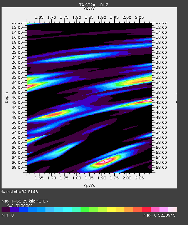
| Estimated Moho Depth: |
65.25 km |
| Estimated Crust Vp/Vs: |
1.91 |
| Assumed Crust Vp: |
6.426 km/s |
| Estimated Crust Vs: |
3.364 km/s |
| Estimated Crust Poisson's Ratio: |
0.31 |
|
| Radial Match: |
94.8145 % |
| Radial Bump: |
361 |
| Transverse Match: |
71.11789 % |
| Transverse Bump: |
400 |
| SOD ConfigId: |
339645 |
| Insert Time: |
2011-02-10 08:05:29.734 +0000 |
| GWidth: |
2.5 |
| Max Bumps: |
400 |
| Tol: |
0.001 |
|

Signal To Noise
| Channel | StoN | STA | LTA |
| TA:S32A: :BHZ:20101008T03:35:03.749978Z | 6.911982 | 1.7847873E-6 | 2.5821643E-7 |
| TA:S32A: :BHN:20101008T03:35:03.749978Z | 3.9381926 | 9.3066865E-7 | 2.3631873E-7 |
| TA:S32A: :BHE:20101008T03:35:03.749978Z | 3.5062113 | 8.8874407E-7 | 2.5347705E-7 |
| Arrivals |
| Ps | 9.7 SECOND |
| PpPs | 28 SECOND |
| PsPs/PpSs | 38 SECOND |


