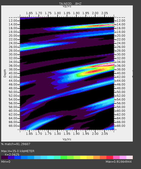
N02D Trinity Center, CA, USA - Earthquake Result Viewer
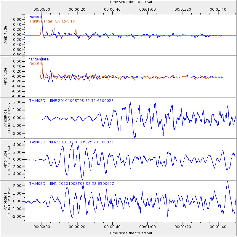
Earthquake location: Andreanof Islands, Aleutian Is.
Earthquake latitude/longitude: 51.4/-175.4
Earthquake time(UTC): 2010/10/08 (281) 03:26:13 GMT
Earthquake Depth: 19 km
Earthquake Magnitude: 6.2 MB, 6.3 MS, 6.4 MW, 6.2 MW
Earthquake Catalog/Contributor: WHDF/NEIC
Network: TA USArray Transportable Network (new EarthScope stations)
Station: N02D Trinity Center, CA, USA
Lat/Lon: 40.97 N/122.71 W
Elevation: 937 m
Distance: 37.2 deg
Az: 85.107 deg
Baz: 304.434 deg
Ray Param: 0.07626056
Estimated Moho Depth: 35.0 km
Estimated Crust Vp/Vs: 2.06
Assumed Crust Vp: 6.566 km/s
Estimated Crust Vs: 3.184 km/s
Estimated Crust Poisson's Ratio: 0.35
Radial Match: 91.29687 %
Radial Bump: 400
Transverse Match: 81.20134 %
Transverse Bump: 400
SOD ConfigId: 339645
Insert Time: 2011-02-10 08:07:04.624 +0000
GWidth: 2.5
Max Bumps: 400
Tol: 0.001

Signal To Noise

ChannelStoNSTALTA
TA:N02D: :BHZ:20101008T03:32:52.650002Z7.83470346.5345444E-78.3405126E-8
TA:N02D: :BHN:20101008T03:32:52.650002Z2.01459433.1746634E-71.5758326E-7
TA:N02D: :BHE:20101008T03:32:52.650002Z3.05622244.876273E-71.595523E-7
Arrivals
Ps6.1 SECOND
PpPs15 SECOND
PsPs/PpSs21 SECOND