You are here: Home > Network List > TA - USArray Transportable Network (new EarthScope stations) Stations List
> Station S35A Otter Creek Ranch, Eureka, KS, USA > Earthquake Result Viewer
S35A Otter Creek Ranch, Eureka, KS, USA - Earthquake Result Viewer
| Earthquake location: |
Andreanof Islands, Aleutian Is. |
| Earthquake latitude/longitude: |
51.4/-175.4 |
| Earthquake time(UTC): |
2010/10/08 (281) 03:26:13 GMT |
| Earthquake Depth: |
19 km |
| Earthquake Magnitude: |
6.2 MB, 6.3 MS, 6.4 MW, 6.2 MW |
| Earthquake Catalog/Contributor: |
WHDF/NEIC |
|
| Network: |
TA USArray Transportable Network (new EarthScope stations) |
| Station: |
S35A Otter Creek Ranch, Eureka, KS, USA |
| Lat/Lon: |
37.68 N/96.32 W |
| Elevation: |
334 m |
|
| Distance: |
55.3 deg |
| Az: |
71.276 deg |
| Baz: |
311.565 deg |
| Ray Param: |
0.06484103 |
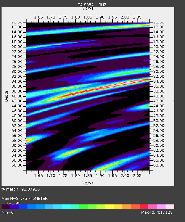
| Estimated Moho Depth: |
34.75 km |
| Estimated Crust Vp/Vs: |
1.99 |
| Assumed Crust Vp: |
6.483 km/s |
| Estimated Crust Vs: |
3.258 km/s |
| Estimated Crust Poisson's Ratio: |
0.33 |
|
| Radial Match: |
93.87926 % |
| Radial Bump: |
384 |
| Transverse Match: |
79.275375 % |
| Transverse Bump: |
400 |
| SOD ConfigId: |
339645 |
| Insert Time: |
2011-02-10 08:07:50.071 +0000 |
| GWidth: |
2.5 |
| Max Bumps: |
400 |
| Tol: |
0.001 |
|
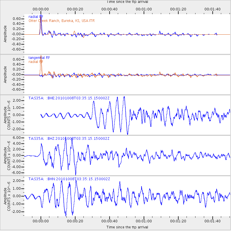
Signal To Noise
| Channel | StoN | STA | LTA |
| TA:S35A: :BHZ:20101008T03:35:15.150002Z | 12.901913 | 2.1984356E-6 | 1.7039609E-7 |
| TA:S35A: :BHN:20101008T03:35:15.150002Z | 3.082214 | 7.525997E-7 | 2.44175E-7 |
| TA:S35A: :BHE:20101008T03:35:15.150002Z | 5.8950067 | 1.1661996E-6 | 1.9782837E-7 |
| Arrivals |
| Ps | 5.6 SECOND |
| PpPs | 15 SECOND |
| PsPs/PpSs | 21 SECOND |


