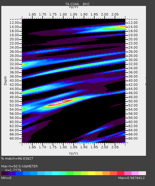
Q34A Chapman, KS, USA - Earthquake Result Viewer

Earthquake location: Andreanof Islands, Aleutian Is.
Earthquake latitude/longitude: 51.4/-175.4
Earthquake time(UTC): 2010/10/08 (281) 03:26:13 GMT
Earthquake Depth: 19 km
Earthquake Magnitude: 6.2 MB, 6.3 MS, 6.4 MW, 6.2 MW
Earthquake Catalog/Contributor: WHDF/NEIC
Network: TA USArray Transportable Network (new EarthScope stations)
Station: Q34A Chapman, KS, USA
Lat/Lon: 38.92 N/96.94 W
Elevation: 378 m
Distance: 54.1 deg
Az: 70.529 deg
Baz: 310.75 deg
Ray Param: 0.06560757
Estimated Moho Depth: 50.5 km
Estimated Crust Vp/Vs: 1.78
Assumed Crust Vp: 6.483 km/s
Estimated Crust Vs: 3.647 km/s
Estimated Crust Poisson's Ratio: 0.27
Radial Match: 96.83627 %
Radial Bump: 319
Transverse Match: 89.336365 %
Transverse Bump: 400
SOD ConfigId: 339645
Insert Time: 2011-02-10 08:08:19.478 +0000
GWidth: 2.5
Max Bumps: 400
Tol: 0.001

Signal To Noise

ChannelStoNSTALTA
TA:Q34A: :BHZ:20101008T03:35:06.57499Z13.9747052.6019657E-61.861911E-7
TA:Q34A: :BHN:20101008T03:35:06.57499Z4.41086151.1997674E-62.7200298E-7
TA:Q34A: :BHE:20101008T03:35:06.57499Z5.0910461.11908E-62.1981339E-7
Arrivals
Ps6.4 SECOND
PpPs20 SECOND
PsPs/PpSs27 SECOND