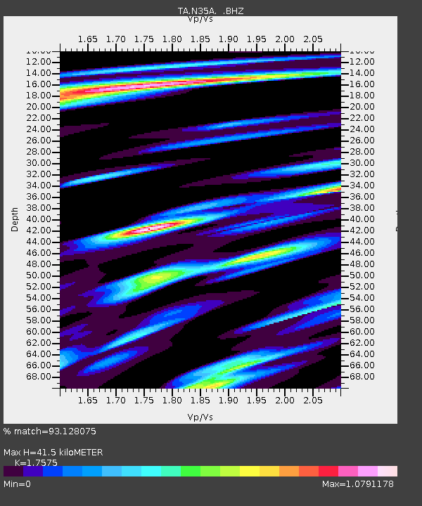
N35A Tabor, IA, USA - Earthquake Result Viewer
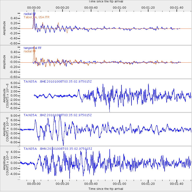
Earthquake location: Andreanof Islands, Aleutian Is.
Earthquake latitude/longitude: 51.4/-175.4
Earthquake time(UTC): 2010/10/08 (281) 03:26:13 GMT
Earthquake Depth: 19 km
Earthquake Magnitude: 6.2 MB, 6.3 MS, 6.4 MW, 6.2 MW
Earthquake Catalog/Contributor: WHDF/NEIC
Network: TA USArray Transportable Network (new EarthScope stations)
Station: N35A Tabor, IA, USA
Lat/Lon: 40.86 N/95.64 W
Elevation: 353 m
Distance: 53.7 deg
Az: 67.902 deg
Baz: 310.032 deg
Ray Param: 0.06593249
Estimated Moho Depth: 41.5 km
Estimated Crust Vp/Vs: 1.76
Assumed Crust Vp: 6.498 km/s
Estimated Crust Vs: 3.697 km/s
Estimated Crust Poisson's Ratio: 0.26
Radial Match: 93.128075 %
Radial Bump: 400
Transverse Match: 84.26053 %
Transverse Bump: 400
SOD ConfigId: 339645
Insert Time: 2011-02-10 08:08:44.097 +0000
GWidth: 2.5
Max Bumps: 400
Tol: 0.001

Signal To Noise

ChannelStoNSTALTA
TA:N35A: :BHZ:20101008T03:35:02.975015Z8.8753443.8671815E-64.357219E-7
TA:N35A: :BHN:20101008T03:35:02.975015Z4.60596371.4736949E-63.199536E-7
TA:N35A: :BHE:20101008T03:35:02.975015Z3.74905561.5650396E-64.17449E-7
Arrivals
Ps5.1 SECOND
PpPs17 SECOND
PsPs/PpSs22 SECOND