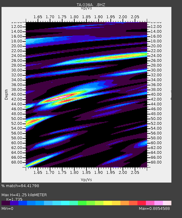
O36A Bolckow, MO, USA - Earthquake Result Viewer

Earthquake location: Andreanof Islands, Aleutian Is.
Earthquake latitude/longitude: 51.4/-175.4
Earthquake time(UTC): 2010/10/08 (281) 03:26:13 GMT
Earthquake Depth: 19 km
Earthquake Magnitude: 6.2 MB, 6.3 MS, 6.4 MW, 6.2 MW
Earthquake Catalog/Contributor: WHDF/NEIC
Network: TA USArray Transportable Network (new EarthScope stations)
Station: O36A Bolckow, MO, USA
Lat/Lon: 40.13 N/94.96 W
Elevation: 306 m
Distance: 54.5 deg
Az: 68.175 deg
Baz: 310.63 deg
Ray Param: 0.06537592
Estimated Moho Depth: 41.25 km
Estimated Crust Vp/Vs: 1.74
Assumed Crust Vp: 6.498 km/s
Estimated Crust Vs: 3.745 km/s
Estimated Crust Poisson's Ratio: 0.25
Radial Match: 94.41798 %
Radial Bump: 400
Transverse Match: 73.32414 %
Transverse Bump: 400
SOD ConfigId: 339645
Insert Time: 2011-02-10 08:09:09.330 +0000
GWidth: 2.5
Max Bumps: 400
Tol: 0.001

Signal To Noise

ChannelStoNSTALTA
TA:O36A: :BHZ:20101008T03:35:09.300027Z14.7346682.958806E-62.0080574E-7
TA:O36A: :BHN:20101008T03:35:09.300027Z4.37955671.2395152E-62.83023E-7
TA:O36A: :BHE:20101008T03:35:09.300027Z7.4183421.4587959E-61.9664716E-7
Arrivals
Ps4.9 SECOND
PpPs16 SECOND
PsPs/PpSs21 SECOND