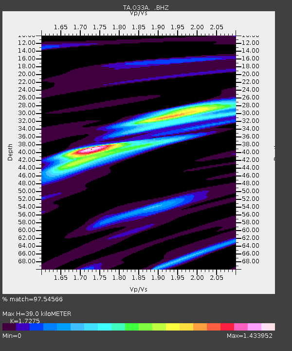
O33A Hebron, NE, USA - Earthquake Result Viewer
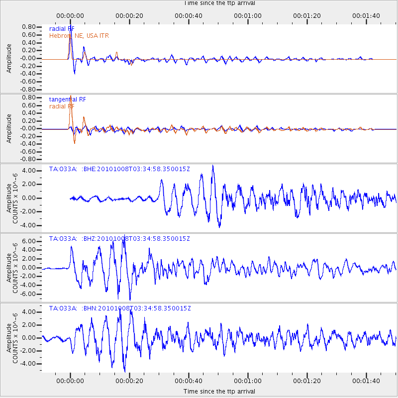
Earthquake location: Andreanof Islands, Aleutian Is.
Earthquake latitude/longitude: 51.4/-175.4
Earthquake time(UTC): 2010/10/08 (281) 03:26:13 GMT
Earthquake Depth: 19 km
Earthquake Magnitude: 6.2 MB, 6.3 MS, 6.4 MW, 6.2 MW
Earthquake Catalog/Contributor: WHDF/NEIC
Network: TA USArray Transportable Network (new EarthScope stations)
Station: O33A Hebron, NE, USA
Lat/Lon: 40.08 N/97.58 W
Elevation: 480 m
Distance: 53.0 deg
Az: 69.838 deg
Baz: 309.932 deg
Ray Param: 0.066355474
Estimated Moho Depth: 39.0 km
Estimated Crust Vp/Vs: 1.73
Assumed Crust Vp: 6.498 km/s
Estimated Crust Vs: 3.761 km/s
Estimated Crust Poisson's Ratio: 0.25
Radial Match: 97.54566 %
Radial Bump: 302
Transverse Match: 88.78233 %
Transverse Bump: 400
SOD ConfigId: 339645
Insert Time: 2011-02-10 08:09:20.700 +0000
GWidth: 2.5
Max Bumps: 400
Tol: 0.001

Signal To Noise

ChannelStoNSTALTA
TA:O33A: :BHZ:20101008T03:34:58.350015Z22.3506452.6213465E-61.17282816E-7
TA:O33A: :BHN:20101008T03:34:58.350015Z8.0075771.3573589E-61.6950932E-7
TA:O33A: :BHE:20101008T03:34:58.350015Z7.5484481.5511339E-62.0549044E-7
Arrivals
Ps4.6 SECOND
PpPs15 SECOND
PsPs/PpSs20 SECOND