U35A Pawnee, OK, USA - Earthquake Result Viewer
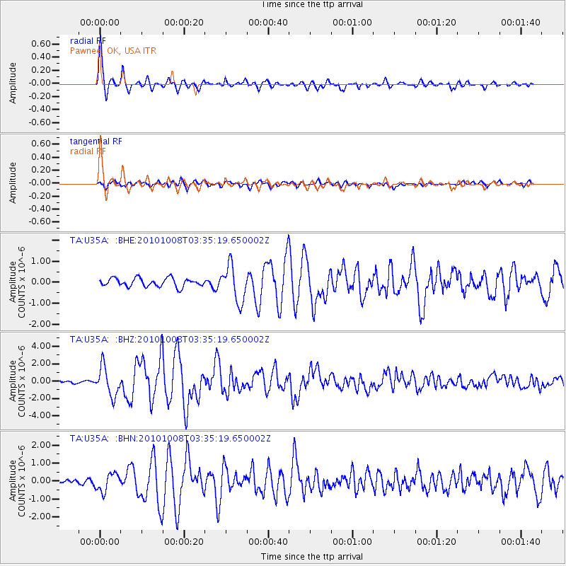
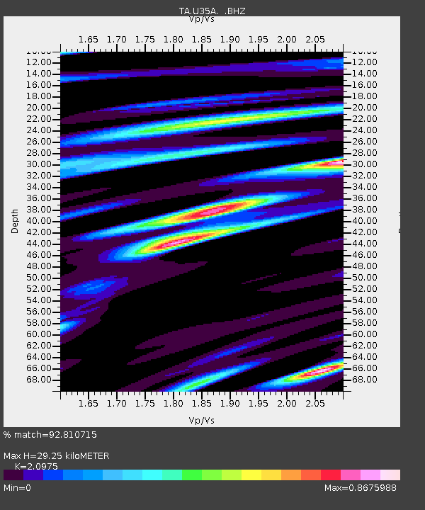
Earthquake location: Andreanof Islands, Aleutian Is.
Earthquake latitude/longitude: 51.4/-175.4
Earthquake time(UTC): 2010/10/08 (281) 03:26:13 GMT
Earthquake Depth: 19 km
Earthquake Magnitude: 6.2 MB, 6.3 MS, 6.4 MW, 6.2 MW
Earthquake Catalog/Contributor: WHDF/NEIC
Network: TA USArray Transportable Network (new EarthScope stations)
Station: U35A Pawnee, OK, USA
Lat/Lon: 36.37 N/96.73 W
Elevation: 303 m
Distance: 56.0 deg
Az: 72.724 deg
Baz: 312.135 deg
Ray Param: 0.06443279
Estimated Moho Depth: 29.25 km
Estimated Crust Vp/Vs: 2.10
Assumed Crust Vp: 6.483 km/s
Estimated Crust Vs: 3.091 km/s
Estimated Crust Poisson's Ratio: 0.35
Radial Match: 92.810715 %
Radial Bump: 400
Transverse Match: 71.73419 %
Transverse Bump: 400
SOD ConfigId: 339645
Insert Time: 2011-02-10 08:10:17.050 +0000
GWidth: 2.5
Max Bumps: 400
Tol: 0.001

Signal To Noise

ChannelStoNSTALTA
TA:U35A: :BHZ:20101008T03:35:19.650002Z7.126631.7106587E-62.4003754E-7
TA:U35A: :BHN:20101008T03:35:19.650002Z2.08535275.159028E-72.4739353E-7
TA:U35A: :BHE:20101008T03:35:19.650002Z4.4091378.819345E-72.000243E-7
Arrivals
Ps5.2 SECOND
PpPs13 SECOND
PsPs/PpSs19 SECOND