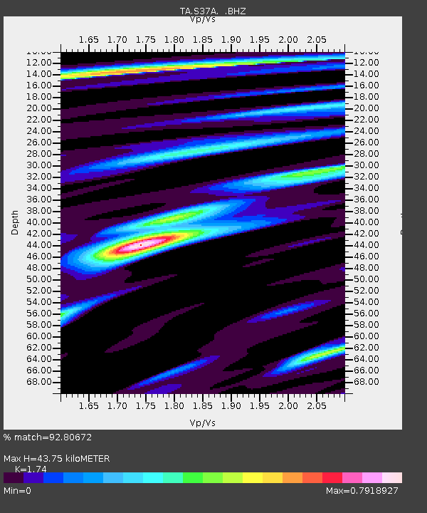
S37A Fort Scott, KS, USA - Earthquake Result Viewer

Earthquake location: Andreanof Islands, Aleutian Is.
Earthquake latitude/longitude: 51.4/-175.4
Earthquake time(UTC): 2010/10/08 (281) 03:26:13 GMT
Earthquake Depth: 19 km
Earthquake Magnitude: 6.2 MB, 6.3 MS, 6.4 MW, 6.2 MW
Earthquake Catalog/Contributor: WHDF/NEIC
Network: TA USArray Transportable Network (new EarthScope stations)
Station: S37A Fort Scott, KS, USA
Lat/Lon: 37.76 N/94.83 W
Elevation: 260 m
Distance: 56.2 deg
Az: 70.254 deg
Baz: 311.898 deg
Ray Param: 0.06430017
Estimated Moho Depth: 43.75 km
Estimated Crust Vp/Vs: 1.74
Assumed Crust Vp: 6.53 km/s
Estimated Crust Vs: 3.753 km/s
Estimated Crust Poisson's Ratio: 0.25
Radial Match: 92.80672 %
Radial Bump: 353
Transverse Match: 70.330284 %
Transverse Bump: 400
SOD ConfigId: 339645
Insert Time: 2011-02-10 08:10:28.582 +0000
GWidth: 2.5
Max Bumps: 400
Tol: 0.001

Signal To Noise

ChannelStoNSTALTA
TA:S37A: :BHZ:20101008T03:35:21.100015Z8.1344071.8784173E-62.3092247E-7
TA:S37A: :BHN:20101008T03:35:21.100015Z3.40879966.5131707E-71.9106933E-7
TA:S37A: :BHE:20101008T03:35:21.100015Z3.5133486.152807E-71.751266E-7
Arrivals
Ps5.2 SECOND
PpPs17 SECOND
PsPs/PpSs23 SECOND