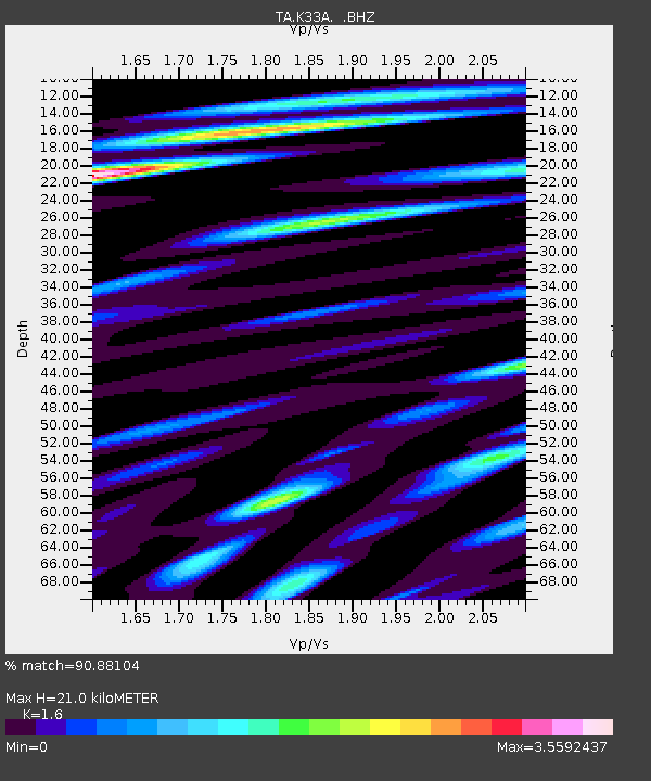
K33A Hardington, NE, USA - Earthquake Result Viewer
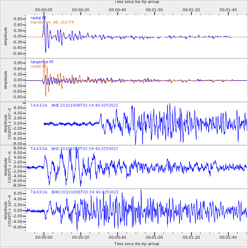
Earthquake location: Andreanof Islands, Aleutian Is.
Earthquake latitude/longitude: 51.4/-175.4
Earthquake time(UTC): 2010/10/08 (281) 03:26:13 GMT
Earthquake Depth: 19 km
Earthquake Magnitude: 6.2 MB, 6.3 MS, 6.4 MW, 6.2 MW
Earthquake Catalog/Contributor: WHDF/NEIC
Network: TA USArray Transportable Network (new EarthScope stations)
Station: K33A Hardington, NE, USA
Lat/Lon: 42.61 N/97.00 W
Elevation: 507 m
Distance: 51.8 deg
Az: 67.017 deg
Baz: 308.594 deg
Ray Param: 0.067177415
Estimated Moho Depth: 21.0 km
Estimated Crust Vp/Vs: 1.60
Assumed Crust Vp: 6.498 km/s
Estimated Crust Vs: 4.061 km/s
Estimated Crust Poisson's Ratio: 0.18
Radial Match: 90.88104 %
Radial Bump: 400
Transverse Match: 70.51322 %
Transverse Bump: 400
SOD ConfigId: 339645
Insert Time: 2011-02-10 08:10:41.359 +0000
GWidth: 2.5
Max Bumps: 400
Tol: 0.001

Signal To Noise

ChannelStoNSTALTA
TA:K33A: :BHZ:20101008T03:34:49.025002Z13.2384073.3247354E-62.5114315E-7
TA:K33A: :BHN:20101008T03:34:49.025002Z6.04760741.6345128E-62.702743E-7
TA:K33A: :BHE:20101008T03:34:49.025002Z6.41248661.9259428E-63.0034258E-7
Arrivals
Ps2.1 SECOND
PpPs7.9 SECOND
PsPs/PpSs10.0 SECOND