You are here: Home > Network List > AZ - ANZA Regional Network Stations List
> Station CRY AZ.CRY > Earthquake Result Viewer
CRY AZ.CRY - Earthquake Result Viewer
| Earthquake location: |
Tonga Islands |
| Earthquake latitude/longitude: |
-17.2/-173.9 |
| Earthquake time(UTC): |
2000/09/26 (270) 06:17:52 GMT |
| Earthquake Depth: |
56 km |
| Earthquake Magnitude: |
6.1 MB, 6.1 MS, 6.4 MW, 6.1 ME |
| Earthquake Catalog/Contributor: |
WHDF/NEIC |
|
| Network: |
AZ ANZA Regional Network |
| Station: |
CRY AZ.CRY |
| Lat/Lon: |
33.57 N/116.74 W |
| Elevation: |
1128 m |
|
| Distance: |
74.3 deg |
| Az: |
46.805 deg |
| Baz: |
236.582 deg |
| Ray Param: |
0.052328564 |
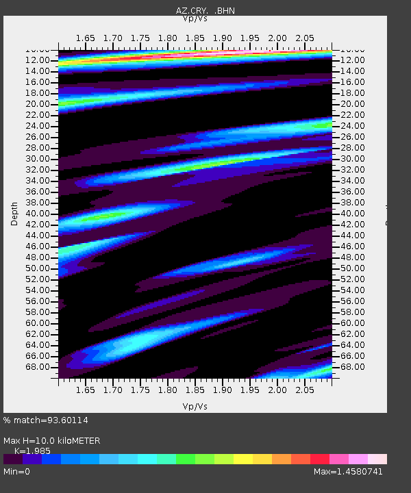
| Estimated Moho Depth: |
10.0 km |
| Estimated Crust Vp/Vs: |
1.99 |
| Assumed Crust Vp: |
6.264 km/s |
| Estimated Crust Vs: |
3.155 km/s |
| Estimated Crust Poisson's Ratio: |
0.33 |
|
| Radial Match: |
93.60114 % |
| Radial Bump: |
400 |
| Transverse Match: |
84.403 % |
| Transverse Bump: |
400 |
| SOD ConfigId: |
3744 |
| Insert Time: |
2010-02-26 19:02:00.024 +0000 |
| GWidth: |
2.5 |
| Max Bumps: |
400 |
| Tol: |
0.001 |
|
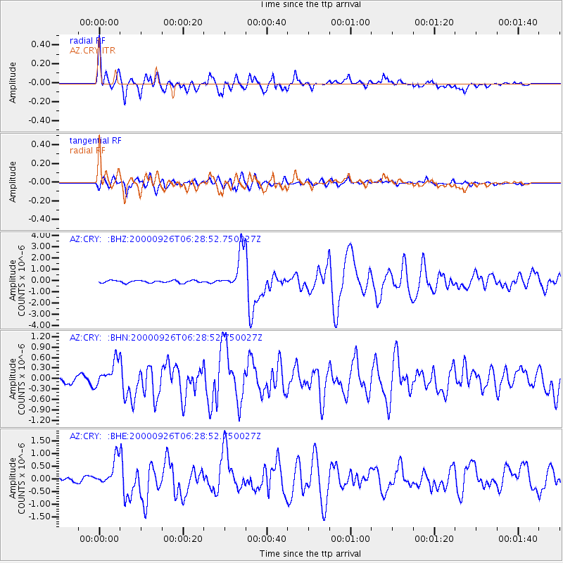
Signal To Noise
| Channel | StoN | STA | LTA |
| AZ:CRY: :BHN:20000926T06:28:52.750027Z | 3.5078864 | 3.7506433E-7 | 1.06920325E-7 |
| AZ:CRY: :BHE:20000926T06:28:52.750027Z | 9.005883 | 5.6740447E-7 | 6.300376E-8 |
| AZ:CRY: :BHZ:20000926T06:28:52.750027Z | 16.987202 | 1.8462204E-6 | 1.0868302E-7 |
| Arrivals |
| Ps | 1.6 SECOND |
| PpPs | 4.6 SECOND |
| PsPs/PpSs | 6.3 SECOND |


