K34A Le Mars, IA, USA - Earthquake Result Viewer
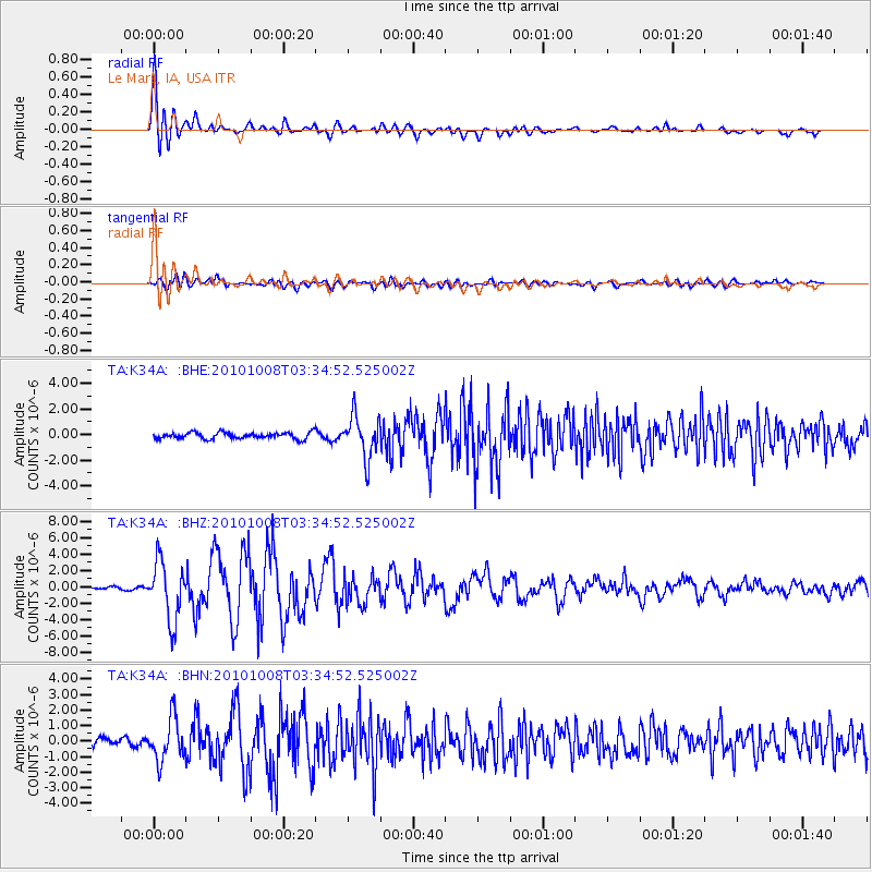
Earthquake location: Andreanof Islands, Aleutian Is.
Earthquake latitude/longitude: 51.4/-175.4
Earthquake time(UTC): 2010/10/08 (281) 03:26:13 GMT
Earthquake Depth: 19 km
Earthquake Magnitude: 6.2 MB, 6.3 MS, 6.4 MW, 6.2 MW
Earthquake Catalog/Contributor: WHDF/NEIC
Network: TA USArray Transportable Network (new EarthScope stations)
Station: K34A Le Mars, IA, USA
Lat/Lon: 42.69 N/96.10 W
Elevation: 436 m
Distance: 52.2 deg
Az: 66.407 deg
Baz: 308.83 deg
Ray Param: 0.0668682
Estimated Moho Depth: 49.75 km
Estimated Crust Vp/Vs: 1.83
Assumed Crust Vp: 6.498 km/s
Estimated Crust Vs: 3.555 km/s
Estimated Crust Poisson's Ratio: 0.29
Radial Match: 94.1994 %
Radial Bump: 400
Transverse Match: 79.1906 %
Transverse Bump: 400
SOD ConfigId: 339645
Insert Time: 2011-02-10 08:11:09.122 +0000
GWidth: 2.5
Max Bumps: 400
Tol: 0.001

Signal To Noise

ChannelStoNSTALTA
TA:K34A: :BHZ:20101008T03:34:52.525002Z26.3611243.592886E-61.3629487E-7
TA:K34A: :BHN:20101008T03:34:52.525002Z7.151921.3530564E-61.8918786E-7
TA:K34A: :BHE:20101008T03:34:52.525002Z6.66383841.6312566E-62.4479235E-7
Arrivals
Ps6.7 SECOND
PpPs20 SECOND
PsPs/PpSs27 SECOND