You are here: Home > Network List > TM - Thai Seismic Monitoring Network Stations List
> Station MHIT Mueang, MaeHongSon > Earthquake Result Viewer
MHIT Mueang, MaeHongSon - Earthquake Result Viewer
| Earthquake location: |
Bismarck Sea |
| Earthquake latitude/longitude: |
-4.6/149.6 |
| Earthquake time(UTC): |
2024/03/29 (089) 09:57:05 GMT |
| Earthquake Depth: |
577 km |
| Earthquake Magnitude: |
5.6 Mww |
| Earthquake Catalog/Contributor: |
NEIC PDE/us |
|
| Network: |
TM Thai Seismic Monitoring Network |
| Station: |
MHIT Mueang, MaeHongSon |
| Lat/Lon: |
19.31 N/97.96 E |
| Elevation: |
270 m |
|
| Distance: |
56.0 deg |
| Az: |
296.807 deg |
| Baz: |
109.588 deg |
| Ray Param: |
0.061968878 |
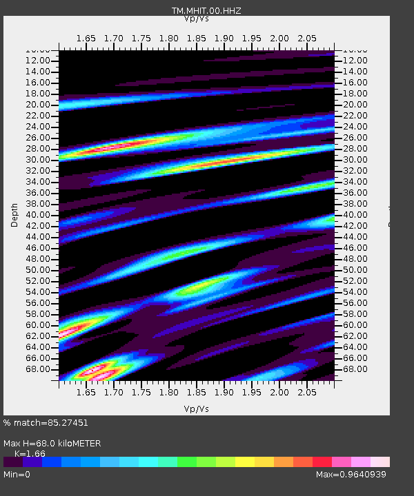
| Estimated Moho Depth: |
68.0 km |
| Estimated Crust Vp/Vs: |
1.66 |
| Assumed Crust Vp: |
6.316 km/s |
| Estimated Crust Vs: |
3.805 km/s |
| Estimated Crust Poisson's Ratio: |
0.22 |
|
| Radial Match: |
85.27451 % |
| Radial Bump: |
372 |
| Transverse Match: |
84.01012 % |
| Transverse Bump: |
349 |
| SOD ConfigId: |
34025071 |
| Insert Time: |
2024-04-12 10:12:57.792 +0000 |
| GWidth: |
2.5 |
| Max Bumps: |
400 |
| Tol: |
0.001 |
|

Signal To Noise
| Channel | StoN | STA | LTA |
| TM:MHIT:00:HHZ:20240329T10:05:19.99999Z | 1.1140728 | 1.33659555E-8 | 1.199738E-8 |
| TM:MHIT:00:HHN:20240329T10:05:19.99999Z | 1.0520325 | 1.3258197E-8 | 1.2602461E-8 |
| TM:MHIT:00:HHE:20240329T10:05:19.99999Z | 0.9478372 | 1.8737534E-8 | 1.9768727E-8 |
| Arrivals |
| Ps | 7.5 SECOND |
| PpPs | 27 SECOND |
| PsPs/PpSs | 35 SECOND |


