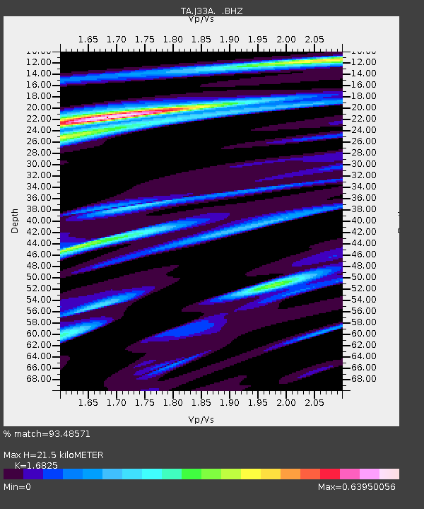
J33A Davis, SD, USA - Earthquake Result Viewer

Earthquake location: Andreanof Islands, Aleutian Is.
Earthquake latitude/longitude: 51.4/-175.4
Earthquake time(UTC): 2010/10/08 (281) 03:26:13 GMT
Earthquake Depth: 19 km
Earthquake Magnitude: 6.2 MB, 6.3 MS, 6.4 MW, 6.2 MW
Earthquake Catalog/Contributor: WHDF/NEIC
Network: TA USArray Transportable Network (new EarthScope stations)
Station: J33A Davis, SD, USA
Lat/Lon: 43.32 N/96.97 W
Elevation: 400 m
Distance: 51.3 deg
Az: 66.284 deg
Baz: 308.162 deg
Ray Param: 0.06745389
Estimated Moho Depth: 21.5 km
Estimated Crust Vp/Vs: 1.68
Assumed Crust Vp: 6.498 km/s
Estimated Crust Vs: 3.862 km/s
Estimated Crust Poisson's Ratio: 0.23
Radial Match: 93.48571 %
Radial Bump: 330
Transverse Match: 81.85611 %
Transverse Bump: 400
SOD ConfigId: 339645
Insert Time: 2011-02-10 08:11:18.383 +0000
GWidth: 2.5
Max Bumps: 400
Tol: 0.001

Signal To Noise

ChannelStoNSTALTA
TA:J33A: :BHZ:20101008T03:34:45.874978Z13.576723.1966426E-62.354503E-7
TA:J33A: :BHN:20101008T03:34:45.874978Z4.4374919.908409E-72.2328857E-7
TA:J33A: :BHE:20101008T03:34:45.874978Z6.73611161.3421562E-61.9924794E-7
Arrivals
Ps2.4 SECOND
PpPs8.3 SECOND
PsPs/PpSs11 SECOND