You are here: Home > Network List > UW - Pacific Northwest Regional Seismic Network Stations List
> Station UMAT Pilot Rock, OR, USA > Earthquake Result Viewer
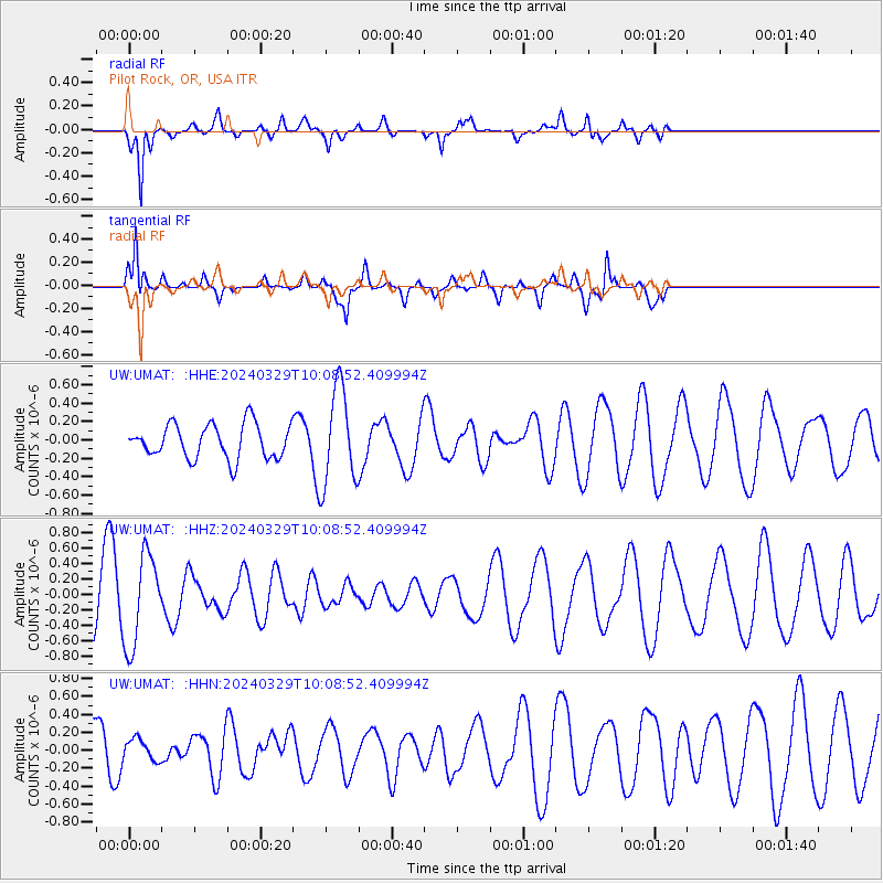
UMAT Pilot Rock, OR, USA - Earthquake Result Viewer
*The percent match for this event was below the threshold and hence no stack was calculated.
| Earthquake location: |
Bismarck Sea |
| Earthquake latitude/longitude: |
-4.6/149.6 |
| Earthquake time(UTC): |
2024/03/29 (089) 09:57:05 GMT |
| Earthquake Depth: |
577 km |
| Earthquake Magnitude: |
5.6 Mww |
| Earthquake Catalog/Contributor: |
NEIC PDE/us |
|
| Network: |
UW Pacific Northwest Regional Seismic Network |
| Station: |
UMAT Pilot Rock, OR, USA |
| Lat/Lon: |
45.29 N/118.96 W |
| Elevation: |
1318 m |
|
| Distance: |
94.2 deg |
| Az: |
45.04 deg |
| Baz: |
267.834 deg |
| Ray Param: |
$rayparam |
*The percent match for this event was below the threshold and hence was not used in the summary stack. |
|
| Radial Match: |
75.63471 % |
| Radial Bump: |
352 |
| Transverse Match: |
54.762104 % |
| Transverse Bump: |
326 |
| SOD ConfigId: |
34025071 |
| Insert Time: |
2024-04-12 10:15:21.524 +0000 |
| GWidth: |
2.5 |
| Max Bumps: |
400 |
| Tol: |
0.001 |
|
Signal To Noise
| Channel | StoN | STA | LTA |
| UW:UMAT: :HHZ:20240329T10:08:52.409994Z | 1.89196 | 5.869861E-7 | 3.1025291E-7 |
| UW:UMAT: :HHN:20240329T10:08:52.409994Z | 0.42374682 | 1.2334488E-7 | 2.9108153E-7 |
| UW:UMAT: :HHE:20240329T10:08:52.409994Z | 2.833534 | 5.235646E-7 | 1.8477442E-7 |
| Arrivals |
| Ps | |
| PpPs | |
| PsPs/PpSs | |


