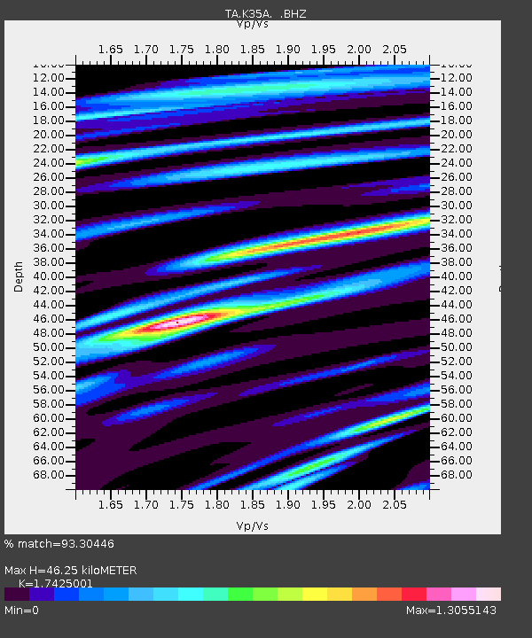
K35A Storm Lake, IA, USA - Earthquake Result Viewer
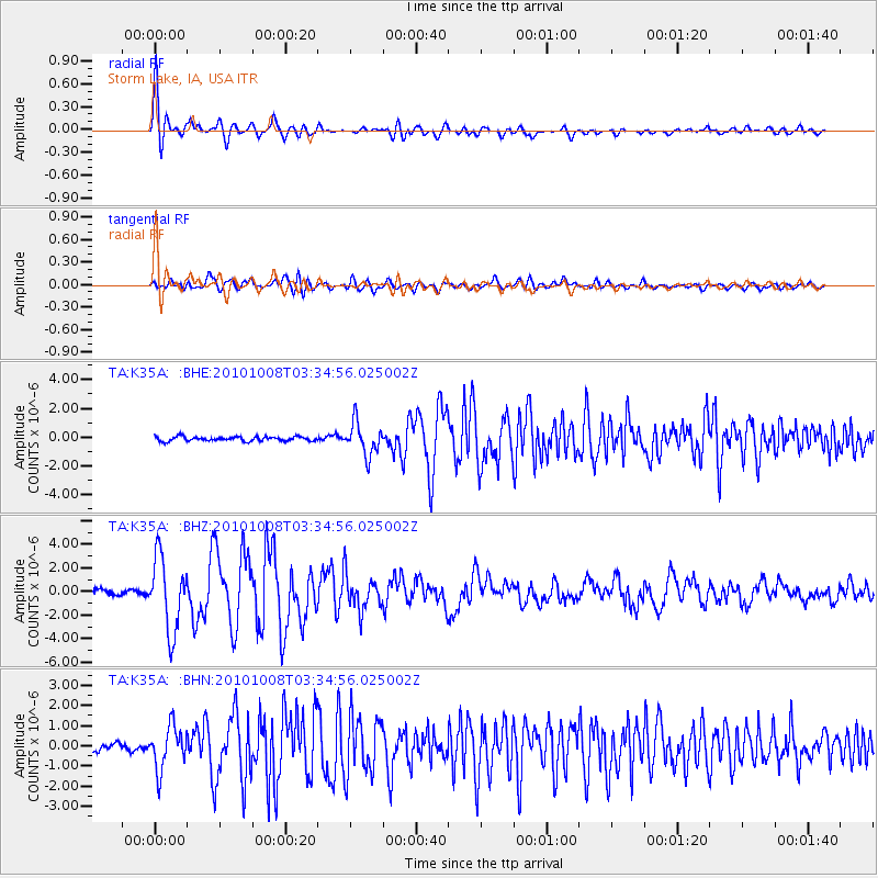
Earthquake location: Andreanof Islands, Aleutian Is.
Earthquake latitude/longitude: 51.4/-175.4
Earthquake time(UTC): 2010/10/08 (281) 03:26:13 GMT
Earthquake Depth: 19 km
Earthquake Magnitude: 6.2 MB, 6.3 MS, 6.4 MW, 6.2 MW
Earthquake Catalog/Contributor: WHDF/NEIC
Network: TA USArray Transportable Network (new EarthScope stations)
Station: K35A Storm Lake, IA, USA
Lat/Lon: 42.72 N/95.23 W
Elevation: 439 m
Distance: 52.7 deg
Az: 65.868 deg
Baz: 309.084 deg
Ray Param: 0.06656608
Estimated Moho Depth: 46.25 km
Estimated Crust Vp/Vs: 1.74
Assumed Crust Vp: 6.53 km/s
Estimated Crust Vs: 3.748 km/s
Estimated Crust Poisson's Ratio: 0.25
Radial Match: 93.30446 %
Radial Bump: 400
Transverse Match: 81.735085 %
Transverse Bump: 400
SOD ConfigId: 339645
Insert Time: 2011-02-10 08:11:31.401 +0000
GWidth: 2.5
Max Bumps: 400
Tol: 0.001

Signal To Noise

ChannelStoNSTALTA
TA:K35A: :BHZ:20101008T03:34:56.025002Z13.0204213.07737E-62.363495E-7
TA:K35A: :BHN:20101008T03:34:56.025002Z2.75575731.0579922E-63.839207E-7
TA:K35A: :BHE:20101008T03:34:56.025002Z7.2429281.110375E-61.5330471E-7
Arrivals
Ps5.6 SECOND
PpPs18 SECOND
PsPs/PpSs24 SECOND