O03D Paynes Creek, CA, USA - Earthquake Result Viewer
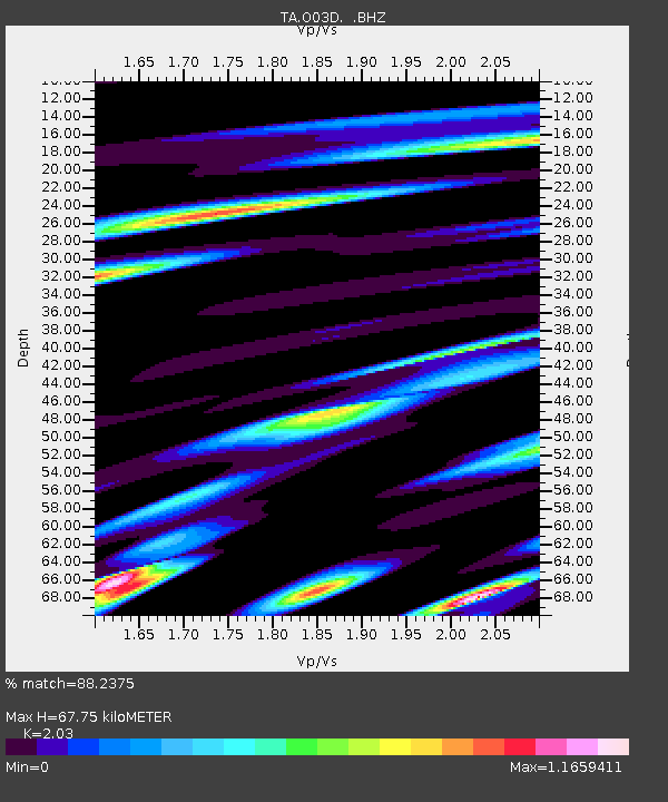
Earthquake location: Andreanof Islands, Aleutian Is.
Earthquake latitude/longitude: 51.4/-175.4
Earthquake time(UTC): 2010/10/08 (281) 03:26:13 GMT
Earthquake Depth: 19 km
Earthquake Magnitude: 6.2 MB, 6.3 MS, 6.4 MW, 6.2 MW
Earthquake Catalog/Contributor: WHDF/NEIC
Network: TA USArray Transportable Network (new EarthScope stations)
Station: O03D Paynes Creek, CA, USA
Lat/Lon: 40.29 N/121.80 W
Elevation: 968 m
Distance: 38.1 deg
Az: 85.376 deg
Baz: 305.233 deg
Ray Param: 0.07572211
Estimated Moho Depth: 67.75 km
Estimated Crust Vp/Vs: 2.03
Assumed Crust Vp: 6.566 km/s
Estimated Crust Vs: 3.235 km/s
Estimated Crust Poisson's Ratio: 0.34
Radial Match: 88.2375 %
Radial Bump: 400
Transverse Match: 77.46505 %
Transverse Bump: 400
SOD ConfigId: 339645
Insert Time: 2011-02-10 08:12:11.418 +0000
GWidth: 2.5
Max Bumps: 400
Tol: 0.001

Signal To Noise

ChannelStoNSTALTA
TA:O03D: :BHZ:20101008T03:33:00.69999Z6.4746166.700922E-71.0349529E-7
TA:O03D: :BHN:20101008T03:33:00.69999Z1.69840062.9649973E-71.7457585E-7
TA:O03D: :BHE:20101008T03:33:00.69999Z2.93768984.3909097E-71.4946812E-7
Arrivals
Ps11 SECOND
PpPs29 SECOND
PsPs/PpSs41 SECOND