You are here: Home > Network List > TA - USArray Transportable Network (new EarthScope stations) Stations List
> Station B31A Greenbush Farm, Park River, ND, USA > Earthquake Result Viewer
B31A Greenbush Farm, Park River, ND, USA - Earthquake Result Viewer
| Earthquake location: |
Andreanof Islands, Aleutian Is. |
| Earthquake latitude/longitude: |
51.4/-175.4 |
| Earthquake time(UTC): |
2010/10/08 (281) 03:26:13 GMT |
| Earthquake Depth: |
19 km |
| Earthquake Magnitude: |
6.2 MB, 6.3 MS, 6.4 MW, 6.2 MW |
| Earthquake Catalog/Contributor: |
WHDF/NEIC |
|
| Network: |
TA USArray Transportable Network (new EarthScope stations) |
| Station: |
B31A Greenbush Farm, Park River, ND, USA |
| Lat/Lon: |
48.42 N/97.65 W |
| Elevation: |
279 m |
|
| Distance: |
47.9 deg |
| Az: |
61.253 deg |
| Baz: |
304.412 deg |
| Ray Param: |
0.06965647 |
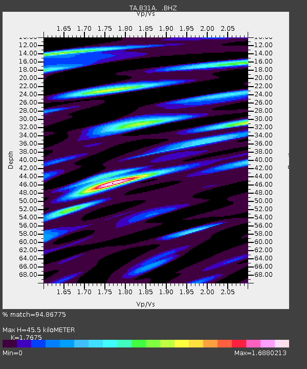
| Estimated Moho Depth: |
45.5 km |
| Estimated Crust Vp/Vs: |
1.77 |
| Assumed Crust Vp: |
6.498 km/s |
| Estimated Crust Vs: |
3.676 km/s |
| Estimated Crust Poisson's Ratio: |
0.26 |
|
| Radial Match: |
94.86775 % |
| Radial Bump: |
400 |
| Transverse Match: |
81.768234 % |
| Transverse Bump: |
400 |
| SOD ConfigId: |
339645 |
| Insert Time: |
2011-02-10 08:12:49.119 +0000 |
| GWidth: |
2.5 |
| Max Bumps: |
400 |
| Tol: |
0.001 |
|

Signal To Noise
| Channel | StoN | STA | LTA |
| TA:B31A: :BHZ:20101008T03:34:19.94999Z | 22.043102 | 4.835918E-6 | 2.1938465E-7 |
| TA:B31A: :BHN:20101008T03:34:19.94999Z | 10.472738 | 2.066554E-6 | 1.9732701E-7 |
| TA:B31A: :BHE:20101008T03:34:19.94999Z | 14.470801 | 3.1741713E-6 | 2.1935007E-7 |
| Arrivals |
| Ps | 5.7 SECOND |
| PpPs | 18 SECOND |
| PsPs/PpSs | 24 SECOND |


