You are here: Home > Network List > DK - Danish Seismological Network Stations List
> Station ILULI Ilulissat, Greenland > Earthquake Result Viewer
ILULI Ilulissat, Greenland - Earthquake Result Viewer
| Earthquake location: |
Rat Islands, Aleutian Islands |
| Earthquake latitude/longitude: |
52.1/178.4 |
| Earthquake time(UTC): |
2024/03/30 (090) 16:28:57 GMT |
| Earthquake Depth: |
115 km |
| Earthquake Magnitude: |
5.8 mww |
| Earthquake Catalog/Contributor: |
NEIC PDE/us |
|
| Network: |
DK Danish Seismological Network |
| Station: |
ILULI Ilulissat, Greenland |
| Lat/Lon: |
69.21 N/51.10 W |
| Elevation: |
54 m |
|
| Distance: |
53.7 deg |
| Az: |
19.691 deg |
| Baz: |
324.391 deg |
| Ray Param: |
0.06557939 |
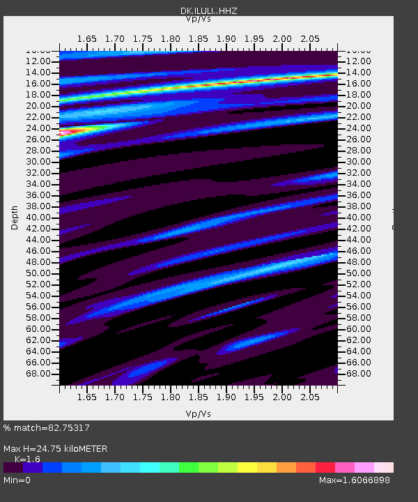
| Estimated Moho Depth: |
24.75 km |
| Estimated Crust Vp/Vs: |
1.60 |
| Assumed Crust Vp: |
6.459 km/s |
| Estimated Crust Vs: |
4.037 km/s |
| Estimated Crust Poisson's Ratio: |
0.18 |
|
| Radial Match: |
82.75317 % |
| Radial Bump: |
400 |
| Transverse Match: |
80.173996 % |
| Transverse Bump: |
400 |
| SOD ConfigId: |
34025071 |
| Insert Time: |
2024-04-13 16:39:41.630 +0000 |
| GWidth: |
2.5 |
| Max Bumps: |
400 |
| Tol: |
0.001 |
|

Signal To Noise
| Channel | StoN | STA | LTA |
| DK:ILULI: :HHZ:20240330T16:37:37.219976Z | 2.8005245 | 5.649693E-7 | 2.0173697E-7 |
| DK:ILULI: :HHN:20240330T16:37:37.219976Z | 1.7725836 | 2.2679083E-7 | 1.2794365E-7 |
| DK:ILULI: :HHE:20240330T16:37:37.219976Z | 1.0920665 | 2.00715E-7 | 1.8379374E-7 |
| Arrivals |
| Ps | 2.4 SECOND |
| PpPs | 9.4 SECOND |
| PsPs/PpSs | 12 SECOND |


