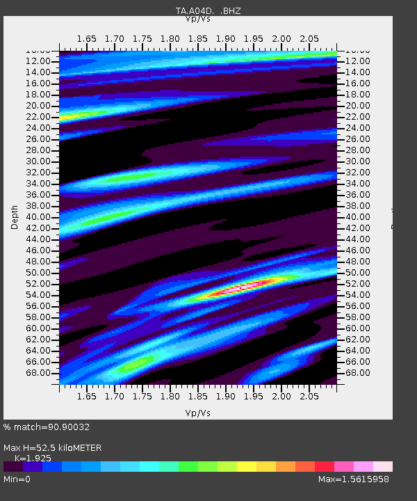
A04D Lummi Island, WA, USA - Earthquake Result Viewer
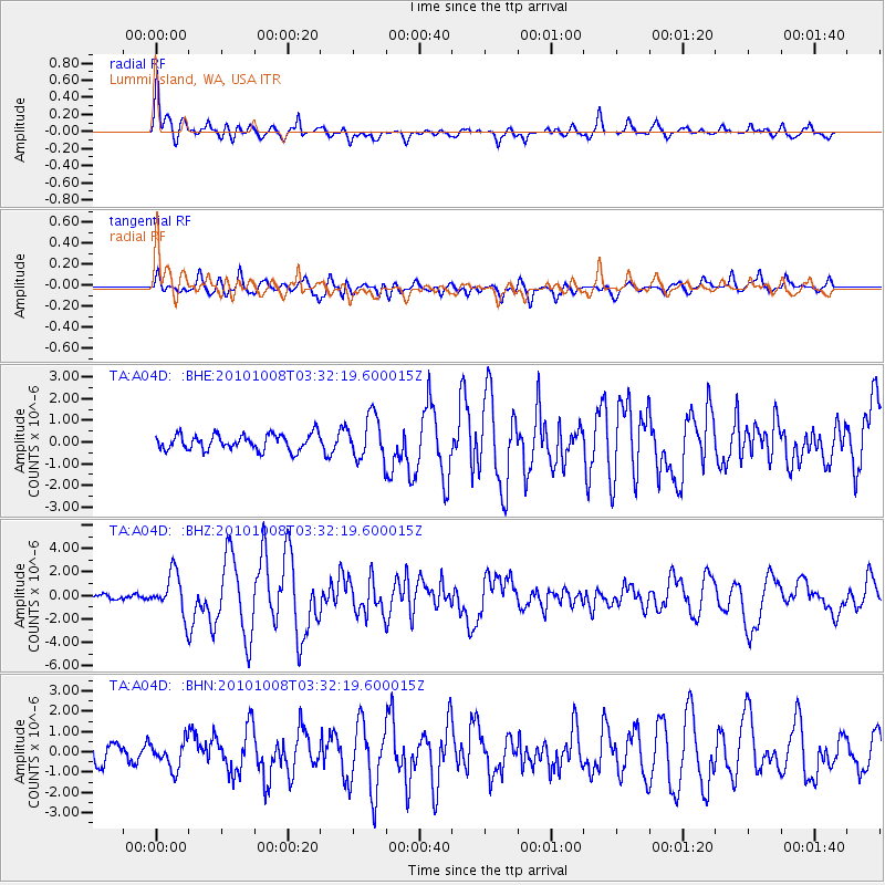
Earthquake location: Andreanof Islands, Aleutian Is.
Earthquake latitude/longitude: 51.4/-175.4
Earthquake time(UTC): 2010/10/08 (281) 03:26:13 GMT
Earthquake Depth: 19 km
Earthquake Magnitude: 6.2 MB, 6.3 MS, 6.4 MW, 6.2 MW
Earthquake Catalog/Contributor: WHDF/NEIC
Network: TA USArray Transportable Network (new EarthScope stations)
Station: A04D Lummi Island, WA, USA
Lat/Lon: 48.72 N/122.71 W
Elevation: 13 m
Distance: 33.3 deg
Az: 73.432 deg
Baz: 294.882 deg
Ray Param: 0.07824386
Estimated Moho Depth: 52.5 km
Estimated Crust Vp/Vs: 1.92
Assumed Crust Vp: 6.566 km/s
Estimated Crust Vs: 3.411 km/s
Estimated Crust Poisson's Ratio: 0.32
Radial Match: 90.90032 %
Radial Bump: 400
Transverse Match: 84.121284 %
Transverse Bump: 400
SOD ConfigId: 339645
Insert Time: 2011-02-10 08:13:12.551 +0000
GWidth: 2.5
Max Bumps: 400
Tol: 0.001

Signal To Noise

ChannelStoNSTALTA
TA:A04D: :BHZ:20101008T03:32:19.600015Z6.71583031.74137E-62.5929333E-7
TA:A04D: :BHN:20101008T03:32:19.600015Z1.51435036.53192E-74.3133483E-7
TA:A04D: :BHE:20101008T03:32:19.600015Z2.74873169.918836E-73.6085137E-7
Arrivals
Ps8.0 SECOND
PpPs22 SECOND
PsPs/PpSs30 SECOND