You are here: Home > Network List > IW - Intermountain West Stations List
> Station MOOW Moose Ponds, Wyoming, USA > Earthquake Result Viewer
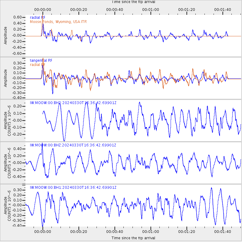
MOOW Moose Ponds, Wyoming, USA - Earthquake Result Viewer
*The percent match for this event was below the threshold and hence no stack was calculated.
| Earthquake location: |
Rat Islands, Aleutian Islands |
| Earthquake latitude/longitude: |
52.1/178.4 |
| Earthquake time(UTC): |
2024/03/30 (090) 16:28:57 GMT |
| Earthquake Depth: |
115 km |
| Earthquake Magnitude: |
5.8 mww |
| Earthquake Catalog/Contributor: |
NEIC PDE/us |
|
| Network: |
IW Intermountain West |
| Station: |
MOOW Moose Ponds, Wyoming, USA |
| Lat/Lon: |
43.75 N/110.74 W |
| Elevation: |
2128 m |
|
| Distance: |
46.4 deg |
| Az: |
70.832 deg |
| Baz: |
306.48 deg |
| Ray Param: |
$rayparam |
*The percent match for this event was below the threshold and hence was not used in the summary stack. |
|
| Radial Match: |
48.761074 % |
| Radial Bump: |
400 |
| Transverse Match: |
62.16765 % |
| Transverse Bump: |
400 |
| SOD ConfigId: |
34025071 |
| Insert Time: |
2024-04-13 16:43:44.655 +0000 |
| GWidth: |
2.5 |
| Max Bumps: |
400 |
| Tol: |
0.001 |
|
Signal To Noise
| Channel | StoN | STA | LTA |
| IW:MOOW:00:BHZ:20240330T16:36:42.69901Z | 3.1881824 | 2.9590257E-7 | 9.281231E-8 |
| IW:MOOW:00:BH1:20240330T16:36:42.69901Z | 2.5076547 | 2.1920879E-7 | 8.7415856E-8 |
| IW:MOOW:00:BH2:20240330T16:36:42.69901Z | 0.81996614 | 1.1348024E-7 | 1.3839625E-7 |
| Arrivals |
| Ps | |
| PpPs | |
| PsPs/PpSs | |


