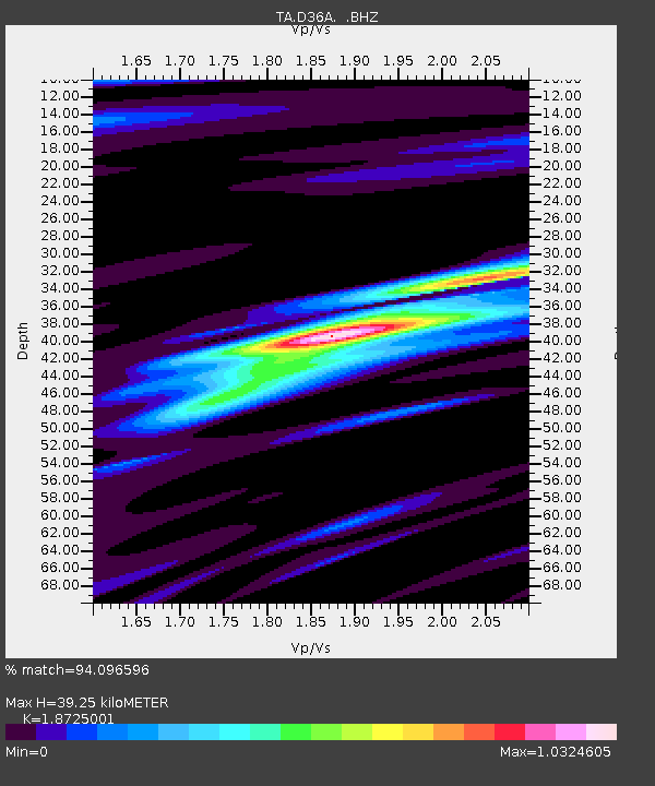
D36A Goodland, MN, USA - Earthquake Result Viewer

Earthquake location: Andreanof Islands, Aleutian Is.
Earthquake latitude/longitude: 51.4/-175.4
Earthquake time(UTC): 2010/10/08 (281) 03:26:13 GMT
Earthquake Depth: 19 km
Earthquake Magnitude: 6.2 MB, 6.3 MS, 6.4 MW, 6.2 MW
Earthquake Catalog/Contributor: WHDF/NEIC
Network: TA USArray Transportable Network (new EarthScope stations)
Station: D36A Goodland, MN, USA
Lat/Lon: 47.18 N/93.16 W
Elevation: 434 m
Distance: 51.1 deg
Az: 60.261 deg
Baz: 307.081 deg
Ray Param: 0.06759518
Estimated Moho Depth: 39.25 km
Estimated Crust Vp/Vs: 1.87
Assumed Crust Vp: 6.571 km/s
Estimated Crust Vs: 3.509 km/s
Estimated Crust Poisson's Ratio: 0.30
Radial Match: 94.096596 %
Radial Bump: 266
Transverse Match: 79.51586 %
Transverse Bump: 400
SOD ConfigId: 339645
Insert Time: 2011-02-10 08:14:50.360 +0000
GWidth: 2.5
Max Bumps: 400
Tol: 0.001

Signal To Noise

ChannelStoNSTALTA
TA:D36A: :BHZ:20101008T03:34:44.174996Z14.3177933.5121532E-62.452999E-7
TA:D36A: :BHN:20101008T03:34:44.174996Z4.9210021.269297E-62.579347E-7
TA:D36A: :BHE:20101008T03:34:44.174996Z10.67890551.578164E-61.4778331E-7
Arrivals
Ps5.5 SECOND
PpPs16 SECOND
PsPs/PpSs22 SECOND