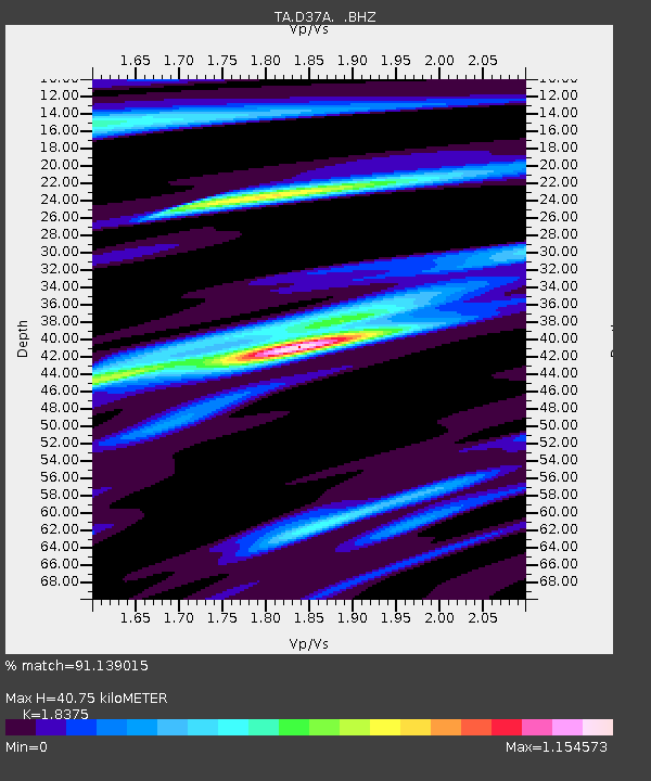
D37A Cotton, MN, USA - Earthquake Result Viewer
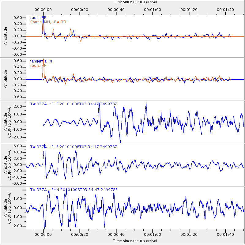
Earthquake location: Andreanof Islands, Aleutian Is.
Earthquake latitude/longitude: 51.4/-175.4
Earthquake time(UTC): 2010/10/08 (281) 03:26:13 GMT
Earthquake Depth: 19 km
Earthquake Magnitude: 6.2 MB, 6.3 MS, 6.4 MW, 6.2 MW
Earthquake Catalog/Contributor: WHDF/NEIC
Network: TA USArray Transportable Network (new EarthScope stations)
Station: D37A Cotton, MN, USA
Lat/Lon: 47.16 N/92.43 W
Elevation: 413 m
Distance: 51.5 deg
Az: 59.89 deg
Baz: 307.389 deg
Ray Param: 0.06733512
Estimated Moho Depth: 40.75 km
Estimated Crust Vp/Vs: 1.84
Assumed Crust Vp: 6.571 km/s
Estimated Crust Vs: 3.576 km/s
Estimated Crust Poisson's Ratio: 0.29
Radial Match: 91.139015 %
Radial Bump: 365
Transverse Match: 78.4224 %
Transverse Bump: 400
SOD ConfigId: 339645
Insert Time: 2011-02-10 08:14:53.692 +0000
GWidth: 2.5
Max Bumps: 400
Tol: 0.001

Signal To Noise

ChannelStoNSTALTA
TA:D37A: :BHZ:20101008T03:34:47.249978Z8.0621462.8879142E-63.5820665E-7
TA:D37A: :BHN:20101008T03:34:47.249978Z4.8669721.1804308E-62.4253904E-7
TA:D37A: :BHE:20101008T03:34:47.249978Z4.16302971.0843668E-62.604754E-7
Arrivals
Ps5.5 SECOND
PpPs17 SECOND
PsPs/PpSs22 SECOND