You are here: Home > Network List > US - United States National Seismic Network Stations List
> Station CBKS Cedar Bluff, Kansas, USA > Earthquake Result Viewer
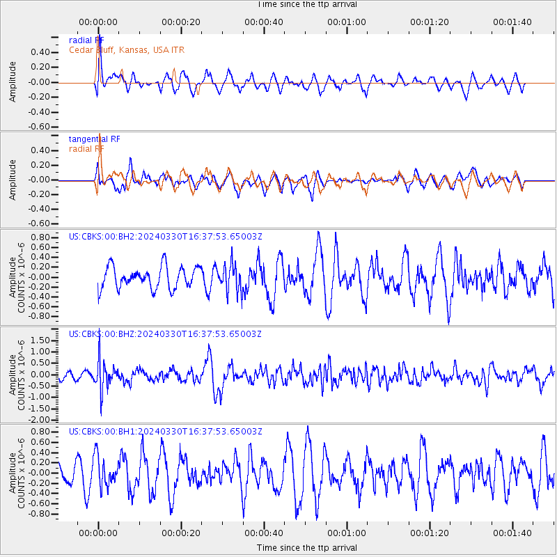
CBKS Cedar Bluff, Kansas, USA - Earthquake Result Viewer
*The percent match for this event was below the threshold and hence no stack was calculated.
| Earthquake location: |
Rat Islands, Aleutian Islands |
| Earthquake latitude/longitude: |
52.1/178.4 |
| Earthquake time(UTC): |
2024/03/30 (090) 16:28:57 GMT |
| Earthquake Depth: |
115 km |
| Earthquake Magnitude: |
5.8 mww |
| Earthquake Catalog/Contributor: |
NEIC PDE/us |
|
| Network: |
US United States National Seismic Network |
| Station: |
CBKS Cedar Bluff, Kansas, USA |
| Lat/Lon: |
38.81 N/99.74 W |
| Elevation: |
677 m |
|
| Distance: |
56.0 deg |
| Az: |
68.928 deg |
| Baz: |
312.537 deg |
| Ray Param: |
$rayparam |
*The percent match for this event was below the threshold and hence was not used in the summary stack. |
|
| Radial Match: |
54.275753 % |
| Radial Bump: |
400 |
| Transverse Match: |
62.81189 % |
| Transverse Bump: |
400 |
| SOD ConfigId: |
34025071 |
| Insert Time: |
2024-04-13 16:58:35.744 +0000 |
| GWidth: |
2.5 |
| Max Bumps: |
400 |
| Tol: |
0.001 |
|
Signal To Noise
| Channel | StoN | STA | LTA |
| US:CBKS:00:BHZ:20240330T16:37:53.65003Z | 2.6159692 | 6.297231E-7 | 2.4072267E-7 |
| US:CBKS:00:BH1:20240330T16:37:53.65003Z | 1.1947411 | 2.8914025E-7 | 2.420108E-7 |
| US:CBKS:00:BH2:20240330T16:37:53.65003Z | 1.2345253 | 2.699619E-7 | 2.1867669E-7 |
| Arrivals |
| Ps | |
| PpPs | |
| PsPs/PpSs | |


