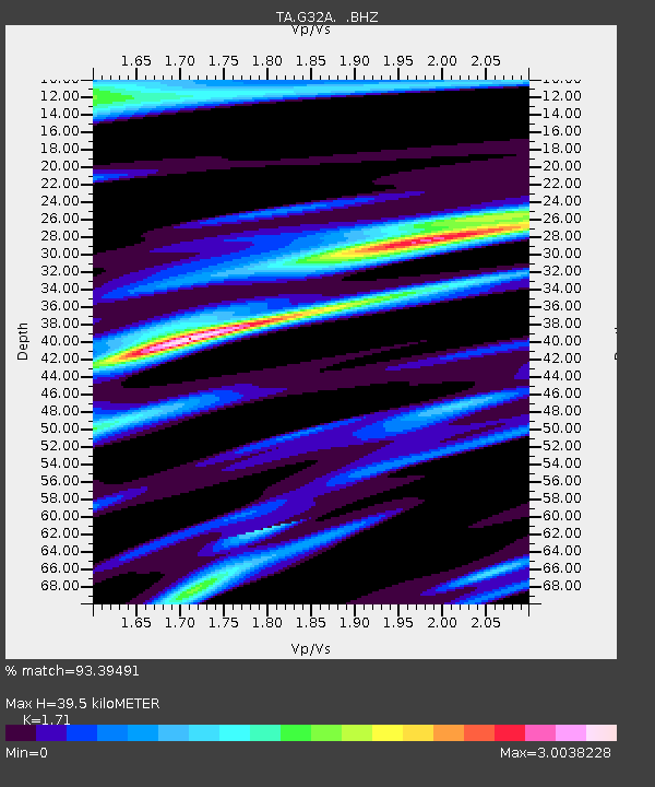
G32A Webster, SD, USA - Earthquake Result Viewer

Earthquake location: Andreanof Islands, Aleutian Is.
Earthquake latitude/longitude: 51.4/-175.4
Earthquake time(UTC): 2010/10/08 (281) 03:26:13 GMT
Earthquake Depth: 19 km
Earthquake Magnitude: 6.2 MB, 6.3 MS, 6.4 MW, 6.2 MW
Earthquake Catalog/Contributor: WHDF/NEIC
Network: TA USArray Transportable Network (new EarthScope stations)
Station: G32A Webster, SD, USA
Lat/Lon: 45.26 N/97.50 W
Elevation: 566 m
Distance: 49.9 deg
Az: 64.595 deg
Baz: 306.719 deg
Ray Param: 0.06841022
Estimated Moho Depth: 39.5 km
Estimated Crust Vp/Vs: 1.71
Assumed Crust Vp: 6.552 km/s
Estimated Crust Vs: 3.832 km/s
Estimated Crust Poisson's Ratio: 0.24
Radial Match: 93.39491 %
Radial Bump: 299
Transverse Match: 69.31659 %
Transverse Bump: 389
SOD ConfigId: 339645
Insert Time: 2011-02-10 08:15:03.784 +0000
GWidth: 2.5
Max Bumps: 400
Tol: 0.001

Signal To Noise

ChannelStoNSTALTA
TA:G32A: :BHZ:20101008T03:34:34.69999Z16.2477383.2642395E-62.0090425E-7
TA:G32A: :BHN:20101008T03:34:34.69999Z2.8743862.8378906E-69.873032E-7
TA:G32A: :BHE:20101008T03:34:34.69999Z6.75479843.7804834E-65.5967377E-7
Arrivals
Ps4.6 SECOND
PpPs15 SECOND
PsPs/PpSs20 SECOND