You are here: Home > Network List > CC - Cascade Chain Volcano Monitoring Stations List
> Station SWF2 Southwest Flank moved down hill, Mt. St. Helens, WA > Earthquake Result Viewer
SWF2 Southwest Flank moved down hill, Mt. St. Helens, WA - Earthquake Result Viewer
| Earthquake location: |
Near East Coast Of Honshu, Japan |
| Earthquake latitude/longitude: |
40.1/141.7 |
| Earthquake time(UTC): |
2024/04/01 (092) 19:24:36 GMT |
| Earthquake Depth: |
73 km |
| Earthquake Magnitude: |
5.9 mww |
| Earthquake Catalog/Contributor: |
NEIC PDE/us |
|
| Network: |
CC Cascade Chain Volcano Monitoring |
| Station: |
SWF2 Southwest Flank moved down hill, Mt. St. Helens, WA |
| Lat/Lon: |
46.18 N/122.22 W |
| Elevation: |
1548 m |
|
| Distance: |
66.1 deg |
| Az: |
49.097 deg |
| Baz: |
303.498 deg |
| Ray Param: |
0.057674333 |
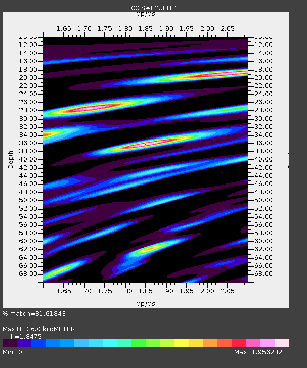
| Estimated Moho Depth: |
36.0 km |
| Estimated Crust Vp/Vs: |
1.85 |
| Assumed Crust Vp: |
6.566 km/s |
| Estimated Crust Vs: |
3.554 km/s |
| Estimated Crust Poisson's Ratio: |
0.29 |
|
| Radial Match: |
81.61843 % |
| Radial Bump: |
400 |
| Transverse Match: |
85.27335 % |
| Transverse Bump: |
400 |
| SOD ConfigId: |
34025071 |
| Insert Time: |
2024-04-15 19:38:09.226 +0000 |
| GWidth: |
2.5 |
| Max Bumps: |
400 |
| Tol: |
0.001 |
|

Signal To Noise
| Channel | StoN | STA | LTA |
| CC:SWF2: :BHZ:20240401T19:34:45.219973Z | 16.24573 | 2.7581739E-6 | 1.6977839E-7 |
| CC:SWF2: :BHN:20240401T19:34:45.219973Z | 3.0186863 | 6.7644623E-7 | 2.2408629E-7 |
| CC:SWF2: :BHE:20240401T19:34:45.219973Z | 1.5647808 | 5.454569E-7 | 3.4858357E-7 |
| Arrivals |
| Ps | 4.8 SECOND |
| PpPs | 15 SECOND |
| PsPs/PpSs | 20 SECOND |


