You are here: Home > Network List > II - Global Seismograph Network (GSN - IRIS/IDA) Stations List
> Station KURK Kurchatov, Kazakhstan > Earthquake Result Viewer
KURK Kurchatov, Kazakhstan - Earthquake Result Viewer
| Earthquake location: |
Near East Coast Of Honshu, Japan |
| Earthquake latitude/longitude: |
40.1/141.7 |
| Earthquake time(UTC): |
2024/04/01 (092) 19:24:36 GMT |
| Earthquake Depth: |
73 km |
| Earthquake Magnitude: |
5.9 mww |
| Earthquake Catalog/Contributor: |
NEIC PDE/us |
|
| Network: |
II Global Seismograph Network (GSN - IRIS/IDA) |
| Station: |
KURK Kurchatov, Kazakhstan |
| Lat/Lon: |
50.72 N/78.62 E |
| Elevation: |
184 m |
|
| Distance: |
44.3 deg |
| Az: |
305.677 deg |
| Baz: |
78.399 deg |
| Ray Param: |
0.071821086 |
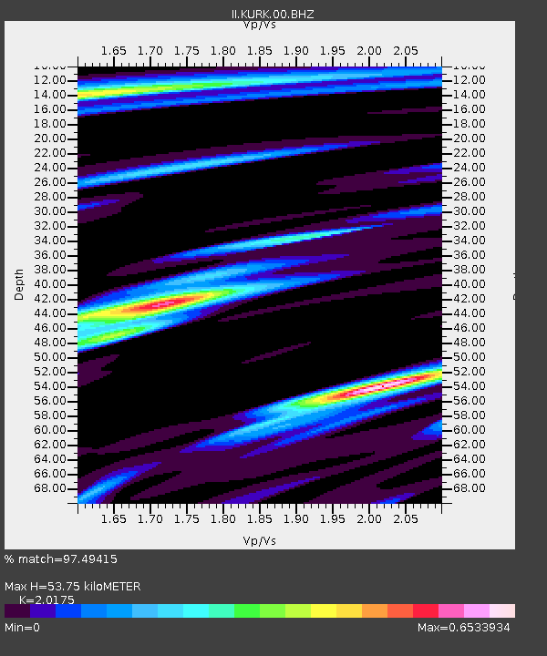
| Estimated Moho Depth: |
53.75 km |
| Estimated Crust Vp/Vs: |
2.02 |
| Assumed Crust Vp: |
6.552 km/s |
| Estimated Crust Vs: |
3.248 km/s |
| Estimated Crust Poisson's Ratio: |
0.34 |
|
| Radial Match: |
97.49415 % |
| Radial Bump: |
346 |
| Transverse Match: |
90.98606 % |
| Transverse Bump: |
400 |
| SOD ConfigId: |
34025071 |
| Insert Time: |
2024-04-15 19:47:25.450 +0000 |
| GWidth: |
2.5 |
| Max Bumps: |
400 |
| Tol: |
0.001 |
|

Signal To Noise
| Channel | StoN | STA | LTA |
| II:KURK:00:BHZ:20240401T19:32:08.468996Z | 157.7086 | 8.3856075E-6 | 5.3171522E-8 |
| II:KURK:00:BH1:20240401T19:32:08.468996Z | 42.521923 | 2.2256102E-6 | 5.2340297E-8 |
| II:KURK:00:BH2:20240401T19:32:08.468996Z | 79.44728 | 3.842389E-6 | 4.8364008E-8 |
| Arrivals |
| Ps | 8.9 SECOND |
| PpPs | 23 SECOND |
| PsPs/PpSs | 32 SECOND |


