You are here: Home > Network List > IW - Intermountain West Stations List
> Station MOOW Moose Ponds, Wyoming, USA > Earthquake Result Viewer
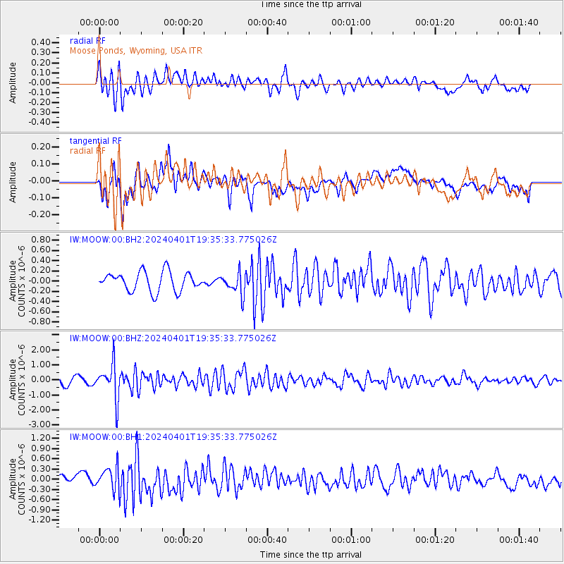
MOOW Moose Ponds, Wyoming, USA - Earthquake Result Viewer
*The percent match for this event was below the threshold and hence no stack was calculated.
| Earthquake location: |
Near East Coast Of Honshu, Japan |
| Earthquake latitude/longitude: |
40.1/141.7 |
| Earthquake time(UTC): |
2024/04/01 (092) 19:24:36 GMT |
| Earthquake Depth: |
73 km |
| Earthquake Magnitude: |
5.9 mww |
| Earthquake Catalog/Contributor: |
NEIC PDE/us |
|
| Network: |
IW Intermountain West |
| Station: |
MOOW Moose Ponds, Wyoming, USA |
| Lat/Lon: |
43.75 N/110.74 W |
| Elevation: |
2128 m |
|
| Distance: |
74.0 deg |
| Az: |
45.944 deg |
| Baz: |
310.515 deg |
| Ray Param: |
$rayparam |
*The percent match for this event was below the threshold and hence was not used in the summary stack. |
|
| Radial Match: |
67.32364 % |
| Radial Bump: |
400 |
| Transverse Match: |
67.3229 % |
| Transverse Bump: |
400 |
| SOD ConfigId: |
34025071 |
| Insert Time: |
2024-04-15 19:48:35.171 +0000 |
| GWidth: |
2.5 |
| Max Bumps: |
400 |
| Tol: |
0.001 |
|
Signal To Noise
| Channel | StoN | STA | LTA |
| IW:MOOW:00:BHZ:20240401T19:35:33.775026Z | 4.923098 | 1.1925584E-6 | 2.422374E-7 |
| IW:MOOW:00:BH1:20240401T19:35:33.775026Z | 2.3270426 | 3.391857E-7 | 1.4575828E-7 |
| IW:MOOW:00:BH2:20240401T19:35:33.775026Z | 1.169303 | 2.2104122E-7 | 1.8903673E-7 |
| Arrivals |
| Ps | |
| PpPs | |
| PsPs/PpSs | |


