You are here: Home > Network List > US - United States National Seismic Network Stations List
> Station DGMT Dagmar, Montana, USA > Earthquake Result Viewer
DGMT Dagmar, Montana, USA - Earthquake Result Viewer
*The percent match for this event was below the threshold and hence no stack was calculated.
| Earthquake location: |
Colombia |
| Earthquake latitude/longitude: |
4.6/-76.6 |
| Earthquake time(UTC): |
2014/01/05 (005) 03:36:40 GMT |
| Earthquake Depth: |
54 km |
| Earthquake Magnitude: |
5.5 MWB, 5.6 MWC |
| Earthquake Catalog/Contributor: |
NEIC PDE/NEIC COMCAT |
|
| Network: |
US United States National Seismic Network |
| Station: |
DGMT Dagmar, Montana, USA |
| Lat/Lon: |
48.47 N/104.20 W |
| Elevation: |
0.0 m |
|
| Distance: |
49.7 deg |
| Az: |
336.187 deg |
| Baz: |
142.786 deg |
| Ray Param: |
$rayparam |
*The percent match for this event was below the threshold and hence was not used in the summary stack. |
|
| Radial Match: |
66.01889 % |
| Radial Bump: |
304 |
| Transverse Match: |
67.0091 % |
| Transverse Bump: |
315 |
| SOD ConfigId: |
3390531 |
| Insert Time: |
2019-04-09 21:25:25.551 +0000 |
| GWidth: |
2.5 |
| Max Bumps: |
400 |
| Tol: |
0.001 |
|
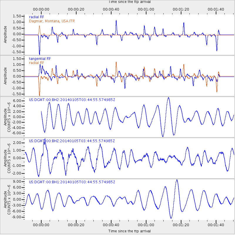
Signal To Noise
| Channel | StoN | STA | LTA |
| US:DGMT:00:BHZ:20140105T03:44:55.574985Z | 1.836892 | 1.3934036E-6 | 7.5856593E-7 |
| US:DGMT:00:BH1:20140105T03:44:55.574985Z | 1.8175447 | 3.5290818E-6 | 1.9416755E-6 |
| US:DGMT:00:BH2:20140105T03:44:55.574985Z | 0.5040005 | 1.5521932E-6 | 3.0797455E-6 |
| Arrivals |
| Ps | |
| PpPs | |
| PsPs/PpSs | |


