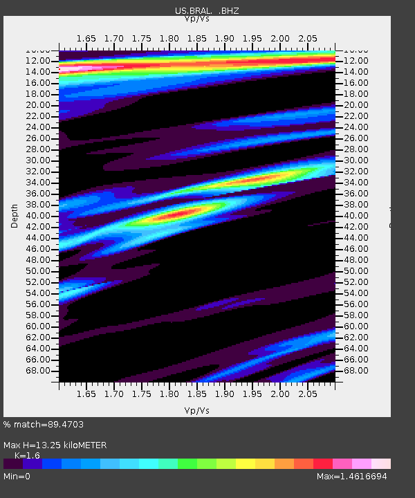
BRAL Brewton, Alabama, USA - Earthquake Result Viewer

Earthquake location: Andreanof Islands, Aleutian Is.
Earthquake latitude/longitude: 51.4/-175.4
Earthquake time(UTC): 2010/10/08 (281) 03:26:13 GMT
Earthquake Depth: 19 km
Earthquake Magnitude: 6.2 MB, 6.3 MS, 6.4 MW, 6.2 MW
Earthquake Catalog/Contributor: WHDF/NEIC
Network: US United States National Seismic Network
Station: BRAL Brewton, Alabama, USA
Lat/Lon: 31.01 N/87.06 W
Elevation: 61 m
Distance: 65.5 deg
Az: 70.641 deg
Baz: 316.469 deg
Ray Param: 0.05824081
Estimated Moho Depth: 13.25 km
Estimated Crust Vp/Vs: 1.60
Assumed Crust Vp: 6.187 km/s
Estimated Crust Vs: 3.867 km/s
Estimated Crust Poisson's Ratio: 0.18
Radial Match: 89.4703 %
Radial Bump: 381
Transverse Match: 85.76804 %
Transverse Bump: 400
SOD ConfigId: 339645
Insert Time: 2011-02-10 08:21:12.482 +0000
GWidth: 2.5
Max Bumps: 400
Tol: 0.001

Signal To Noise

ChannelStoNSTALTA
US:BRAL: :BHZ:20101008T03:36:23.499978Z13.0509473.0722115E-62.3540142E-7
US:BRAL: :BHN:20101008T03:36:23.499978Z1.90192348.7045964E-74.5767334E-7
US:BRAL: :BHE:20101008T03:36:23.499978Z1.3625067.802505E-75.726584E-7
Arrivals
Ps1.3 SECOND
PpPs5.3 SECOND
PsPs/PpSs6.7 SECOND