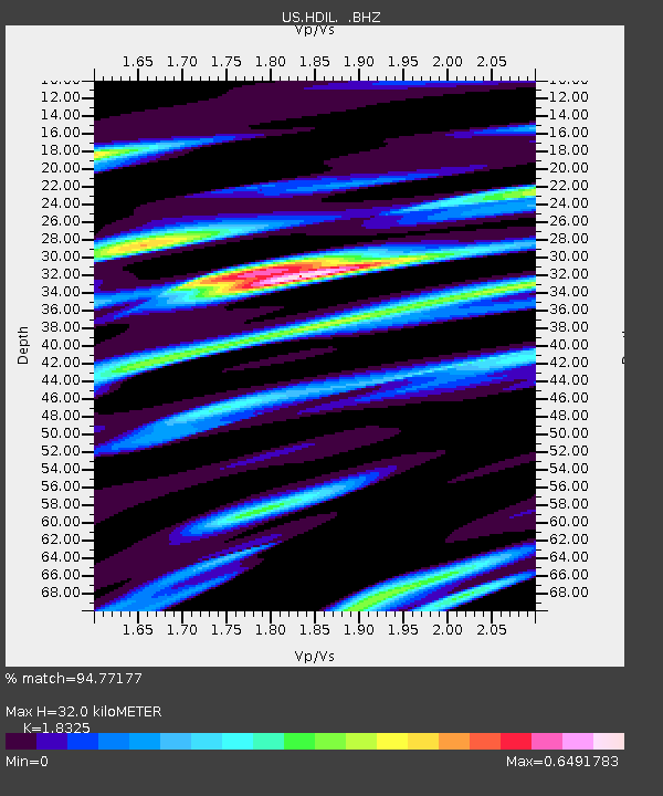
HDIL Hopedale, Illinois, USA - Earthquake Result Viewer
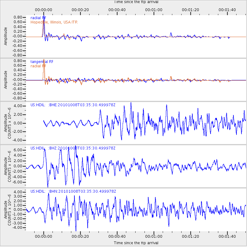
Earthquake location: Andreanof Islands, Aleutian Is.
Earthquake latitude/longitude: 51.4/-175.4
Earthquake time(UTC): 2010/10/08 (281) 03:26:13 GMT
Earthquake Depth: 19 km
Earthquake Magnitude: 6.2 MB, 6.3 MS, 6.4 MW, 6.2 MW
Earthquake Catalog/Contributor: WHDF/NEIC
Network: US United States National Seismic Network
Station: HDIL Hopedale, Illinois, USA
Lat/Lon: 40.56 N/89.29 W
Elevation: 219 m
Distance: 57.5 deg
Az: 64.336 deg
Baz: 312.141 deg
Ray Param: 0.06343552
Estimated Moho Depth: 32.0 km
Estimated Crust Vp/Vs: 1.83
Assumed Crust Vp: 6.498 km/s
Estimated Crust Vs: 3.546 km/s
Estimated Crust Poisson's Ratio: 0.29
Radial Match: 94.77177 %
Radial Bump: 400
Transverse Match: 69.85253 %
Transverse Bump: 400
SOD ConfigId: 339645
Insert Time: 2011-02-10 08:21:13.153 +0000
GWidth: 2.5
Max Bumps: 400
Tol: 0.001

Signal To Noise

ChannelStoNSTALTA
US:HDIL: :BHZ:20101008T03:35:30.499978Z9.7231023.716263E-63.8220966E-7
US:HDIL: :BHN:20101008T03:35:30.499978Z4.5312631.6451371E-63.6306372E-7
US:HDIL: :BHE:20101008T03:35:30.499978Z4.26529651.6634356E-63.8999295E-7
Arrivals
Ps4.3 SECOND
PpPs13 SECOND
PsPs/PpSs18 SECOND