You are here: Home > Network List > US - United States National Seismic Network Stations List
> Station CBKS Cedar Bluff, Kansas, USA > Earthquake Result Viewer
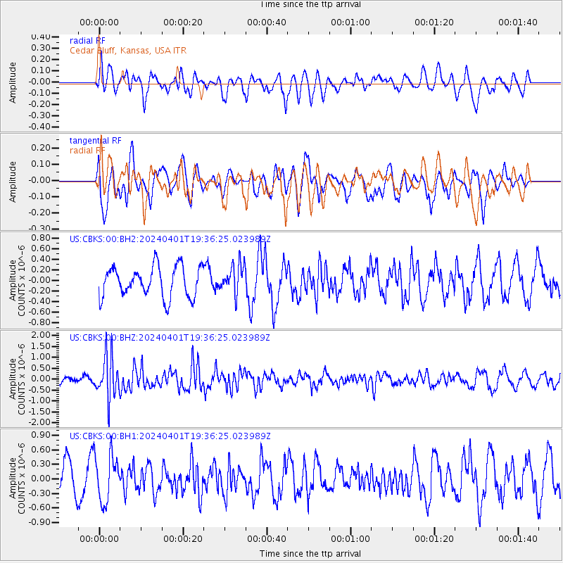
CBKS Cedar Bluff, Kansas, USA - Earthquake Result Viewer
*The percent match for this event was below the threshold and hence no stack was calculated.
| Earthquake location: |
Near East Coast Of Honshu, Japan |
| Earthquake latitude/longitude: |
40.1/141.7 |
| Earthquake time(UTC): |
2024/04/01 (092) 19:24:36 GMT |
| Earthquake Depth: |
73 km |
| Earthquake Magnitude: |
5.9 mww |
| Earthquake Catalog/Contributor: |
NEIC PDE/us |
|
| Network: |
US United States National Seismic Network |
| Station: |
CBKS Cedar Bluff, Kansas, USA |
| Lat/Lon: |
38.81 N/99.74 W |
| Elevation: |
677 m |
|
| Distance: |
83.4 deg |
| Az: |
43.689 deg |
| Baz: |
317.327 deg |
| Ray Param: |
$rayparam |
*The percent match for this event was below the threshold and hence was not used in the summary stack. |
|
| Radial Match: |
65.72712 % |
| Radial Bump: |
400 |
| Transverse Match: |
61.70571 % |
| Transverse Bump: |
400 |
| SOD ConfigId: |
34025071 |
| Insert Time: |
2024-04-15 20:05:48.863 +0000 |
| GWidth: |
2.5 |
| Max Bumps: |
400 |
| Tol: |
0.001 |
|
Signal To Noise
| Channel | StoN | STA | LTA |
| US:CBKS:00:BHZ:20240401T19:36:25.023989Z | 3.4608562 | 9.923756E-7 | 2.867428E-7 |
| US:CBKS:00:BH1:20240401T19:36:25.023989Z | 1.7093832 | 4.5939262E-7 | 2.6874758E-7 |
| US:CBKS:00:BH2:20240401T19:36:25.023989Z | 0.9923157 | 2.8648483E-7 | 2.887033E-7 |
| Arrivals |
| Ps | |
| PpPs | |
| PsPs/PpSs | |


