You are here: Home > Network List > US - United States National Seismic Network Stations List
> Station LAO LASA Array, Montana, USA > Earthquake Result Viewer
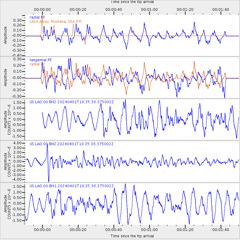
LAO LASA Array, Montana, USA - Earthquake Result Viewer
*The percent match for this event was below the threshold and hence no stack was calculated.
| Earthquake location: |
Near East Coast Of Honshu, Japan |
| Earthquake latitude/longitude: |
40.1/141.7 |
| Earthquake time(UTC): |
2024/04/01 (092) 19:24:36 GMT |
| Earthquake Depth: |
73 km |
| Earthquake Magnitude: |
5.9 mww |
| Earthquake Catalog/Contributor: |
NEIC PDE/us |
|
| Network: |
US United States National Seismic Network |
| Station: |
LAO LASA Array, Montana, USA |
| Lat/Lon: |
46.69 N/106.22 W |
| Elevation: |
902 m |
|
| Distance: |
74.5 deg |
| Az: |
41.458 deg |
| Baz: |
312.499 deg |
| Ray Param: |
$rayparam |
*The percent match for this event was below the threshold and hence was not used in the summary stack. |
|
| Radial Match: |
57.559944 % |
| Radial Bump: |
400 |
| Transverse Match: |
56.59705 % |
| Transverse Bump: |
400 |
| SOD ConfigId: |
34025071 |
| Insert Time: |
2024-04-15 20:06:14.406 +0000 |
| GWidth: |
2.5 |
| Max Bumps: |
400 |
| Tol: |
0.001 |
|
Signal To Noise
| Channel | StoN | STA | LTA |
| US:LAO:00:BHZ:20240401T19:35:36.375002Z | 5.503518 | 1.7748446E-6 | 3.2249272E-7 |
| US:LAO:00:BH1:20240401T19:35:36.375002Z | 0.6972191 | 5.473082E-7 | 7.8498744E-7 |
| US:LAO:00:BH2:20240401T19:35:36.375002Z | 1.6889807 | 8.9244253E-7 | 5.283912E-7 |
| Arrivals |
| Ps | |
| PpPs | |
| PsPs/PpSs | |


