You are here: Home > Network List > US - United States National Seismic Network Stations List
> Station MSO Missoula, Montana, USA > Earthquake Result Viewer
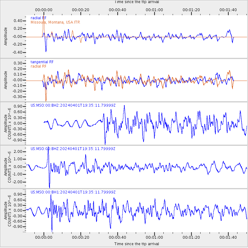
MSO Missoula, Montana, USA - Earthquake Result Viewer
*The percent match for this event was below the threshold and hence no stack was calculated.
| Earthquake location: |
Near East Coast Of Honshu, Japan |
| Earthquake latitude/longitude: |
40.1/141.7 |
| Earthquake time(UTC): |
2024/04/01 (092) 19:24:36 GMT |
| Earthquake Depth: |
73 km |
| Earthquake Magnitude: |
5.9 mww |
| Earthquake Catalog/Contributor: |
NEIC PDE/us |
|
| Network: |
US United States National Seismic Network |
| Station: |
MSO Missoula, Montana, USA |
| Lat/Lon: |
46.83 N/113.94 W |
| Elevation: |
1264 m |
|
| Distance: |
70.3 deg |
| Az: |
44.937 deg |
| Baz: |
307.942 deg |
| Ray Param: |
$rayparam |
*The percent match for this event was below the threshold and hence was not used in the summary stack. |
|
| Radial Match: |
61.403316 % |
| Radial Bump: |
400 |
| Transverse Match: |
68.13105 % |
| Transverse Bump: |
400 |
| SOD ConfigId: |
34025071 |
| Insert Time: |
2024-04-15 20:06:20.880 +0000 |
| GWidth: |
2.5 |
| Max Bumps: |
400 |
| Tol: |
0.001 |
|
Signal To Noise
| Channel | StoN | STA | LTA |
| US:MSO:00:BHZ:20240401T19:35:11.79999Z | 6.1002545 | 1.0727299E-6 | 1.7585003E-7 |
| US:MSO:00:BH1:20240401T19:35:11.79999Z | 2.7498503 | 3.7002343E-7 | 1.345613E-7 |
| US:MSO:00:BH2:20240401T19:35:11.79999Z | 2.9578567 | 3.9456782E-7 | 1.3339653E-7 |
| Arrivals |
| Ps | |
| PpPs | |
| PsPs/PpSs | |


