You are here: Home > Network List > AK - Alaska Regional Network Stations List
> Station C16K Lisburne Hills, AK, USA > Earthquake Result Viewer
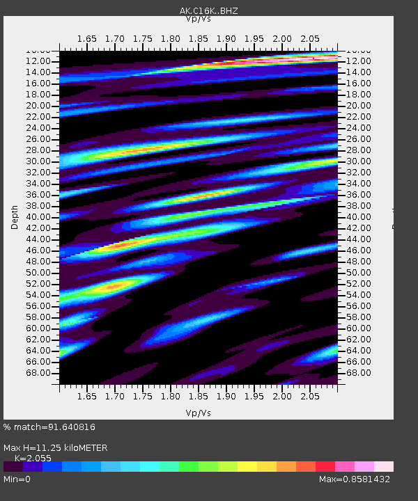
C16K Lisburne Hills, AK, USA - Earthquake Result Viewer
| Earthquake location: |
Mariana Islands |
| Earthquake latitude/longitude: |
15.8/146.9 |
| Earthquake time(UTC): |
2024/04/02 (093) 09:54:09 GMT |
| Earthquake Depth: |
10 km |
| Earthquake Magnitude: |
6.2 mww |
| Earthquake Catalog/Contributor: |
NEIC PDE/us |
|
| Network: |
AK Alaska Regional Network |
| Station: |
C16K Lisburne Hills, AK, USA |
| Lat/Lon: |
68.27 N/165.34 W |
| Elevation: |
102 m |
|
| Distance: |
60.5 deg |
| Az: |
18.469 deg |
| Baz: |
234.992 deg |
| Ray Param: |
0.061493434 |
| Estimated Moho Depth: |
11.25 km |
| Estimated Crust Vp/Vs: |
2.06 |
| Assumed Crust Vp: |
5.906 km/s |
| Estimated Crust Vs: |
2.874 km/s |
| Estimated Crust Poisson's Ratio: |
0.34 |
|
| Radial Match: |
91.640816 % |
| Radial Bump: |
389 |
| Transverse Match: |
75.805115 % |
| Transverse Bump: |
400 |
| SOD ConfigId: |
34025071 |
| Insert Time: |
2024-04-16 09:57:17.566 +0000 |
| GWidth: |
2.5 |
| Max Bumps: |
400 |
| Tol: |
0.001 |
|

Signal To Noise
| Channel | StoN | STA | LTA |
| AK:C16K: :BHZ:20240402T10:03:48.100012Z | 8.5702715 | 5.199562E-7 | 6.066975E-8 |
| AK:C16K: :BHN:20240402T10:03:48.100012Z | 1.7904521 | 1.1771112E-7 | 6.57438E-8 |
| AK:C16K: :BHE:20240402T10:03:48.100012Z | 1.6097792 | 1.8198516E-7 | 1.1304976E-7 |
| Arrivals |
| Ps | 2.1 SECOND |
| PpPs | 5.6 SECOND |
| PsPs/PpSs | 7.7 SECOND |


