You are here: Home > Network List > AK - Alaska Regional Network Stations List
> Station O14K Tigyukauivet Mountain, AK, USA > Earthquake Result Viewer
O14K Tigyukauivet Mountain, AK, USA - Earthquake Result Viewer
| Earthquake location: |
Mariana Islands |
| Earthquake latitude/longitude: |
15.8/146.9 |
| Earthquake time(UTC): |
2024/04/02 (093) 09:54:09 GMT |
| Earthquake Depth: |
10 km |
| Earthquake Magnitude: |
6.2 mww |
| Earthquake Catalog/Contributor: |
NEIC PDE/us |
|
| Network: |
AK Alaska Regional Network |
| Station: |
O14K Tigyukauivet Mountain, AK, USA |
| Lat/Lon: |
59.25 N/161.26 W |
| Elevation: |
129 m |
|
| Distance: |
57.5 deg |
| Az: |
28.643 deg |
| Baz: |
243.912 deg |
| Ray Param: |
0.06347879 |
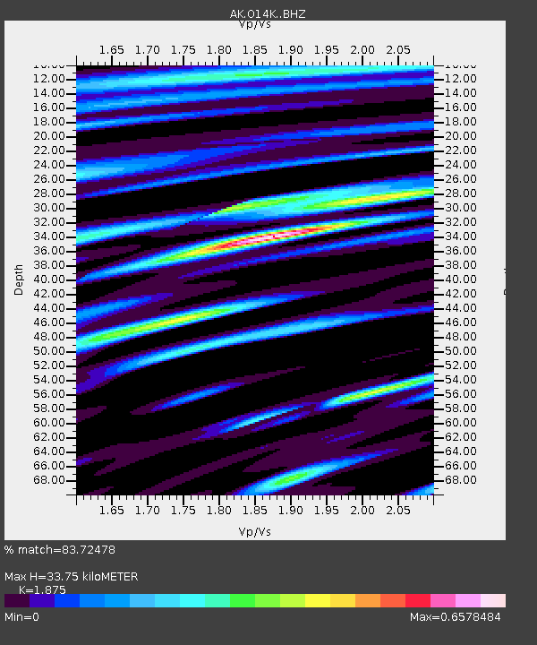
| Estimated Moho Depth: |
33.75 km |
| Estimated Crust Vp/Vs: |
1.88 |
| Assumed Crust Vp: |
6.24 km/s |
| Estimated Crust Vs: |
3.328 km/s |
| Estimated Crust Poisson's Ratio: |
0.30 |
|
| Radial Match: |
83.72478 % |
| Radial Bump: |
400 |
| Transverse Match: |
71.708786 % |
| Transverse Bump: |
400 |
| SOD ConfigId: |
34025071 |
| Insert Time: |
2024-04-16 09:59:11.725 +0000 |
| GWidth: |
2.5 |
| Max Bumps: |
400 |
| Tol: |
0.001 |
|

Signal To Noise
| Channel | StoN | STA | LTA |
| AK:O14K: :BHZ:20240402T10:03:26.999976Z | 2.7634733 | 4.4934484E-7 | 1.6260148E-7 |
| AK:O14K: :BHN:20240402T10:03:26.999976Z | 1.8754766 | 2.7382373E-7 | 1.4600221E-7 |
| AK:O14K: :BHE:20240402T10:03:26.999976Z | 1.9932451 | 2.5060092E-7 | 1.2572508E-7 |
| Arrivals |
| Ps | 4.9 SECOND |
| PpPs | 15 SECOND |
| PsPs/PpSs | 20 SECOND |


