You are here: Home > Network List > AT - Alaska Tsunami Warning Seismic System Stations List
> Station TTA Tatalina, Alaska > Earthquake Result Viewer
TTA Tatalina, Alaska - Earthquake Result Viewer
| Earthquake location: |
Mariana Islands |
| Earthquake latitude/longitude: |
15.8/146.9 |
| Earthquake time(UTC): |
2024/04/02 (093) 09:54:09 GMT |
| Earthquake Depth: |
10 km |
| Earthquake Magnitude: |
6.2 mww |
| Earthquake Catalog/Contributor: |
NEIC PDE/us |
|
| Network: |
AT Alaska Tsunami Warning Seismic System |
| Station: |
TTA Tatalina, Alaska |
| Lat/Lon: |
62.93 N/156.01 W |
| Elevation: |
990 m |
|
| Distance: |
61.3 deg |
| Az: |
25.974 deg |
| Baz: |
247.145 deg |
| Ray Param: |
0.060951132 |
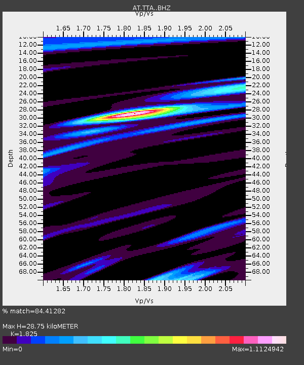
| Estimated Moho Depth: |
28.75 km |
| Estimated Crust Vp/Vs: |
1.83 |
| Assumed Crust Vp: |
6.182 km/s |
| Estimated Crust Vs: |
3.388 km/s |
| Estimated Crust Poisson's Ratio: |
0.29 |
|
| Radial Match: |
84.41282 % |
| Radial Bump: |
400 |
| Transverse Match: |
77.35625 % |
| Transverse Bump: |
400 |
| SOD ConfigId: |
34025071 |
| Insert Time: |
2024-04-16 10:00:19.984 +0000 |
| GWidth: |
2.5 |
| Max Bumps: |
400 |
| Tol: |
0.001 |
|

Signal To Noise
| Channel | StoN | STA | LTA |
| AT:TTA: :BHZ:20240402T10:03:53.559973Z | 2.1071005 | 2.9976482E-7 | 1.4226413E-7 |
| AT:TTA: :BHN:20240402T10:03:53.559973Z | 1.031845 | 1.9729956E-7 | 1.9121048E-7 |
| AT:TTA: :BHE:20240402T10:03:53.559973Z | 1.8621918 | 2.7309852E-7 | 1.4665434E-7 |
| Arrivals |
| Ps | 4.0 SECOND |
| PpPs | 13 SECOND |
| PsPs/PpSs | 17 SECOND |


