You are here: Home > Network List > AU - Australian Seismological Centre Stations List
> Station KIM01 GSWA station > Earthquake Result Viewer
KIM01 GSWA station - Earthquake Result Viewer
| Earthquake location: |
Mariana Islands |
| Earthquake latitude/longitude: |
15.8/146.9 |
| Earthquake time(UTC): |
2024/04/02 (093) 09:54:09 GMT |
| Earthquake Depth: |
10 km |
| Earthquake Magnitude: |
6.2 mww |
| Earthquake Catalog/Contributor: |
NEIC PDE/us |
|
| Network: |
AU Australian Seismological Centre |
| Station: |
KIM01 GSWA station |
| Lat/Lon: |
18.62 S/126.86 E |
| Elevation: |
314 m |
|
| Distance: |
39.5 deg |
| Az: |
210.672 deg |
| Baz: |
31.187 deg |
| Ray Param: |
0.07496589 |
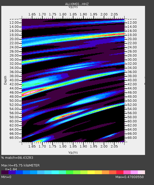
| Estimated Moho Depth: |
45.75 km |
| Estimated Crust Vp/Vs: |
1.64 |
| Assumed Crust Vp: |
6.496 km/s |
| Estimated Crust Vs: |
3.961 km/s |
| Estimated Crust Poisson's Ratio: |
0.20 |
|
| Radial Match: |
86.43293 % |
| Radial Bump: |
400 |
| Transverse Match: |
72.44637 % |
| Transverse Bump: |
400 |
| SOD ConfigId: |
34025071 |
| Insert Time: |
2024-04-16 10:00:42.858 +0000 |
| GWidth: |
2.5 |
| Max Bumps: |
400 |
| Tol: |
0.001 |
|

Signal To Noise
| Channel | StoN | STA | LTA |
| AU:KIM01: :HHZ:20240402T10:01:08.699988Z | 5.6863494 | 9.5017566E-7 | 1.6709765E-7 |
| AU:KIM01: :HHN:20240402T10:01:08.699988Z | 5.6710243 | 2.498183E-7 | 4.4051706E-8 |
| AU:KIM01: :HHE:20240402T10:01:08.699988Z | 2.3598967 | 2.9049642E-7 | 1.2309708E-7 |
| Arrivals |
| Ps | 4.9 SECOND |
| PpPs | 17 SECOND |
| PsPs/PpSs | 22 SECOND |


