You are here: Home > Network List > AU - Australian Seismological Centre Stations List
> Station KIM04 GSWA station > Earthquake Result Viewer
KIM04 GSWA station - Earthquake Result Viewer
| Earthquake location: |
Mariana Islands |
| Earthquake latitude/longitude: |
15.8/146.9 |
| Earthquake time(UTC): |
2024/04/02 (093) 09:54:09 GMT |
| Earthquake Depth: |
10 km |
| Earthquake Magnitude: |
6.2 mww |
| Earthquake Catalog/Contributor: |
NEIC PDE/us |
|
| Network: |
AU Australian Seismological Centre |
| Station: |
KIM04 GSWA station |
| Lat/Lon: |
17.93 S/124.81 E |
| Elevation: |
133 m |
|
| Distance: |
40.0 deg |
| Az: |
213.825 deg |
| Baz: |
34.253 deg |
| Ray Param: |
0.074676685 |
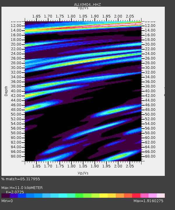
| Estimated Moho Depth: |
11.0 km |
| Estimated Crust Vp/Vs: |
2.07 |
| Assumed Crust Vp: |
6.496 km/s |
| Estimated Crust Vs: |
3.134 km/s |
| Estimated Crust Poisson's Ratio: |
0.35 |
|
| Radial Match: |
85.317955 % |
| Radial Bump: |
400 |
| Transverse Match: |
66.674484 % |
| Transverse Bump: |
400 |
| SOD ConfigId: |
34025071 |
| Insert Time: |
2024-04-16 10:00:46.044 +0000 |
| GWidth: |
2.5 |
| Max Bumps: |
400 |
| Tol: |
0.001 |
|

Signal To Noise
| Channel | StoN | STA | LTA |
| AU:KIM04: :HHZ:20240402T10:01:12.630011Z | 4.1064515 | 4.665833E-6 | 1.13622E-6 |
| AU:KIM04: :HHN:20240402T10:01:12.630011Z | 2.0448287 | 2.270122E-6 | 1.1101771E-6 |
| AU:KIM04: :HHE:20240402T10:01:12.630011Z | 1.0283356 | 1.2345433E-6 | 1.2005257E-6 |
| Arrivals |
| Ps | 1.9 SECOND |
| PpPs | 4.9 SECOND |
| PsPs/PpSs | 6.8 SECOND |


