You are here: Home > Network List > AU - Australian Seismological Centre Stations List
> Station KIM05 GSWA station > Earthquake Result Viewer
KIM05 GSWA station - Earthquake Result Viewer
| Earthquake location: |
Mariana Islands |
| Earthquake latitude/longitude: |
15.8/146.9 |
| Earthquake time(UTC): |
2024/04/02 (093) 09:54:09 GMT |
| Earthquake Depth: |
10 km |
| Earthquake Magnitude: |
6.2 mww |
| Earthquake Catalog/Contributor: |
NEIC PDE/us |
|
| Network: |
AU Australian Seismological Centre |
| Station: |
KIM05 GSWA station |
| Lat/Lon: |
17.99 S/124.19 E |
| Elevation: |
70 m |
|
| Distance: |
40.3 deg |
| Az: |
214.524 deg |
| Baz: |
34.978 deg |
| Ray Param: |
0.07445612 |
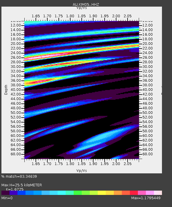
| Estimated Moho Depth: |
25.5 km |
| Estimated Crust Vp/Vs: |
1.67 |
| Assumed Crust Vp: |
6.496 km/s |
| Estimated Crust Vs: |
3.884 km/s |
| Estimated Crust Poisson's Ratio: |
0.22 |
|
| Radial Match: |
83.34639 % |
| Radial Bump: |
337 |
| Transverse Match: |
79.973885 % |
| Transverse Bump: |
400 |
| SOD ConfigId: |
34025071 |
| Insert Time: |
2024-04-16 10:00:47.599 +0000 |
| GWidth: |
2.5 |
| Max Bumps: |
400 |
| Tol: |
0.001 |
|

Signal To Noise
| Channel | StoN | STA | LTA |
| AU:KIM05: :HHZ:20240402T10:01:15.840002Z | 6.278766 | 9.935126E-7 | 1.5823372E-7 |
| AU:KIM05: :HHN:20240402T10:01:15.840002Z | 1.9892383 | 4.8559787E-7 | 2.4411244E-7 |
| AU:KIM05: :HHE:20240402T10:01:15.840002Z | 1.4835155 | 4.105048E-7 | 2.7671084E-7 |
| Arrivals |
| Ps | 2.8 SECOND |
| PpPs | 9.7 SECOND |
| PsPs/PpSs | 13 SECOND |


