You are here: Home > Network List > AU - Australian Seismological Centre Stations List
> Station KMBL Kambalda, WA > Earthquake Result Viewer
KMBL Kambalda, WA - Earthquake Result Viewer
| Earthquake location: |
Mariana Islands |
| Earthquake latitude/longitude: |
15.8/146.9 |
| Earthquake time(UTC): |
2024/04/02 (093) 09:54:09 GMT |
| Earthquake Depth: |
10 km |
| Earthquake Magnitude: |
6.2 mww |
| Earthquake Catalog/Contributor: |
NEIC PDE/us |
|
| Network: |
AU Australian Seismological Centre |
| Station: |
KMBL Kambalda, WA |
| Lat/Lon: |
31.37 S/121.88 E |
| Elevation: |
370 m |
|
| Distance: |
52.7 deg |
| Az: |
207.015 deg |
| Baz: |
30.741 deg |
| Ray Param: |
0.066596076 |
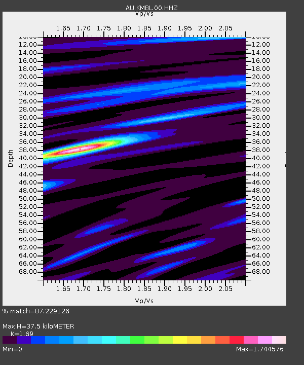
| Estimated Moho Depth: |
37.5 km |
| Estimated Crust Vp/Vs: |
1.69 |
| Assumed Crust Vp: |
6.459 km/s |
| Estimated Crust Vs: |
3.822 km/s |
| Estimated Crust Poisson's Ratio: |
0.23 |
|
| Radial Match: |
87.229126 % |
| Radial Bump: |
257 |
| Transverse Match: |
77.77028 % |
| Transverse Bump: |
400 |
| SOD ConfigId: |
34025071 |
| Insert Time: |
2024-04-16 10:00:57.744 +0000 |
| GWidth: |
2.5 |
| Max Bumps: |
400 |
| Tol: |
0.001 |
|

Signal To Noise
| Channel | StoN | STA | LTA |
| AU:KMBL:00:HHZ:20240402T10:02:52.559973Z | 3.6012404 | 3.2612934E-7 | 9.056028E-8 |
| AU:KMBL:00:HHN:20240402T10:02:52.559973Z | 2.2906926 | 1.6739891E-7 | 7.307786E-8 |
| AU:KMBL:00:HHE:20240402T10:02:52.559973Z | 1.0996389 | 9.805719E-8 | 8.917217E-8 |
| Arrivals |
| Ps | 4.2 SECOND |
| PpPs | 15 SECOND |
| PsPs/PpSs | 19 SECOND |


