You are here: Home > Network List > CC - Cascade Chain Volcano Monitoring Stations List
> Station KWBU Kawak Butte > Earthquake Result Viewer
KWBU Kawak Butte - Earthquake Result Viewer
| Earthquake location: |
Mariana Islands |
| Earthquake latitude/longitude: |
15.8/146.9 |
| Earthquake time(UTC): |
2024/04/02 (093) 09:54:09 GMT |
| Earthquake Depth: |
10 km |
| Earthquake Magnitude: |
6.2 mww |
| Earthquake Catalog/Contributor: |
NEIC PDE/us |
|
| Network: |
CC Cascade Chain Volcano Monitoring |
| Station: |
KWBU Kawak Butte |
| Lat/Lon: |
43.75 N/121.31 W |
| Elevation: |
1783 m |
|
| Distance: |
80.5 deg |
| Az: |
47.247 deg |
| Baz: |
282.731 deg |
| Ray Param: |
0.048211697 |
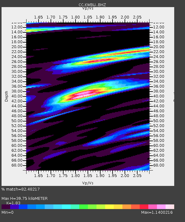
| Estimated Moho Depth: |
39.75 km |
| Estimated Crust Vp/Vs: |
1.83 |
| Assumed Crust Vp: |
6.597 km/s |
| Estimated Crust Vs: |
3.605 km/s |
| Estimated Crust Poisson's Ratio: |
0.29 |
|
| Radial Match: |
82.48217 % |
| Radial Bump: |
400 |
| Transverse Match: |
81.00603 % |
| Transverse Bump: |
400 |
| SOD ConfigId: |
34025071 |
| Insert Time: |
2024-04-16 10:05:47.820 +0000 |
| GWidth: |
2.5 |
| Max Bumps: |
400 |
| Tol: |
0.001 |
|

Signal To Noise
| Channel | StoN | STA | LTA |
| CC:KWBU: :BHZ:20240402T10:05:49.900Z | 5.0726438 | 6.6493965E-7 | 1.3108345E-7 |
| CC:KWBU: :BHN:20240402T10:05:49.900Z | 0.6913148 | 2.375411E-7 | 3.436077E-7 |
| CC:KWBU: :BHE:20240402T10:05:49.900Z | 0.9888406 | 1.5654346E-7 | 1.5831012E-7 |
| Arrivals |
| Ps | 5.1 SECOND |
| PpPs | 17 SECOND |
| PsPs/PpSs | 22 SECOND |


