You are here: Home > Network List > CC - Cascade Chain Volcano Monitoring Stations List
> Station PR04 Puyallup River 04 > Earthquake Result Viewer
PR04 Puyallup River 04 - Earthquake Result Viewer
| Earthquake location: |
Mariana Islands |
| Earthquake latitude/longitude: |
15.8/146.9 |
| Earthquake time(UTC): |
2024/04/02 (093) 09:54:09 GMT |
| Earthquake Depth: |
10 km |
| Earthquake Magnitude: |
6.2 mww |
| Earthquake Catalog/Contributor: |
NEIC PDE/us |
|
| Network: |
CC Cascade Chain Volcano Monitoring |
| Station: |
PR04 Puyallup River 04 |
| Lat/Lon: |
46.93 N/121.99 W |
| Elevation: |
908 m |
|
| Distance: |
79.4 deg |
| Az: |
44.196 deg |
| Baz: |
281.719 deg |
| Ray Param: |
0.04899703 |
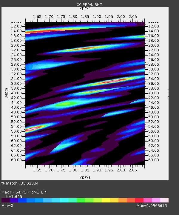
| Estimated Moho Depth: |
54.75 km |
| Estimated Crust Vp/Vs: |
1.62 |
| Assumed Crust Vp: |
6.597 km/s |
| Estimated Crust Vs: |
4.06 km/s |
| Estimated Crust Poisson's Ratio: |
0.20 |
|
| Radial Match: |
83.62384 % |
| Radial Bump: |
400 |
| Transverse Match: |
74.99905 % |
| Transverse Bump: |
400 |
| SOD ConfigId: |
34025071 |
| Insert Time: |
2024-04-16 10:06:04.781 +0000 |
| GWidth: |
2.5 |
| Max Bumps: |
400 |
| Tol: |
0.001 |
|

Signal To Noise
| Channel | StoN | STA | LTA |
| CC:PR04: :BHZ:20240402T10:05:43.759985Z | 2.5004296 | 4.919135E-7 | 1.967316E-7 |
| CC:PR04: :BHN:20240402T10:05:43.759985Z | 0.5225199 | 1.3291945E-7 | 2.543816E-7 |
| CC:PR04: :BHE:20240402T10:05:43.759985Z | 1.2706113 | 2.7425594E-7 | 2.1584567E-7 |
| Arrivals |
| Ps | 5.4 SECOND |
| PpPs | 21 SECOND |
| PsPs/PpSs | 26 SECOND |


