You are here: Home > Network List > CC - Cascade Chain Volcano Monitoring Stations List
> Station ELBE Elbe Fire Station > Earthquake Result Viewer
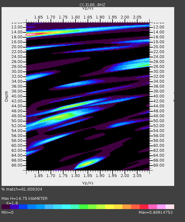
ELBE Elbe Fire Station - Earthquake Result Viewer
| Earthquake location: |
Mariana Islands |
| Earthquake latitude/longitude: |
15.8/146.9 |
| Earthquake time(UTC): |
2024/04/02 (093) 09:54:09 GMT |
| Earthquake Depth: |
10 km |
| Earthquake Magnitude: |
6.2 mww |
| Earthquake Catalog/Contributor: |
NEIC PDE/us |
|
| Network: |
CC Cascade Chain Volcano Monitoring |
| Station: |
ELBE Elbe Fire Station |
| Lat/Lon: |
46.77 N/122.19 W |
| Elevation: |
386 m |
|
| Distance: |
79.3 deg |
| Az: |
44.388 deg |
| Baz: |
281.606 deg |
| Ray Param: |
0.049069095 |
| Estimated Moho Depth: |
14.75 km |
| Estimated Crust Vp/Vs: |
1.60 |
| Assumed Crust Vp: |
6.566 km/s |
| Estimated Crust Vs: |
4.104 km/s |
| Estimated Crust Poisson's Ratio: |
0.18 |
|
| Radial Match: |
81.808304 % |
| Radial Bump: |
400 |
| Transverse Match: |
74.579605 % |
| Transverse Bump: |
400 |
| SOD ConfigId: |
34025071 |
| Insert Time: |
2024-04-16 10:06:36.918 +0000 |
| GWidth: |
2.5 |
| Max Bumps: |
400 |
| Tol: |
0.001 |
|

Signal To Noise
| Channel | StoN | STA | LTA |
| CC:ELBE: :BHZ:20240402T10:05:43.199988Z | 4.176005 | 6.740449E-7 | 1.6140902E-7 |
| CC:ELBE: :BHN:20240402T10:05:43.199988Z | 0.89999104 | 1.933522E-7 | 2.1483791E-7 |
| CC:ELBE: :BHE:20240402T10:05:43.199988Z | 1.5926471 | 2.6038296E-7 | 1.634907E-7 |
| Arrivals |
| Ps | 1.4 SECOND |
| PpPs | 5.6 SECOND |
| PsPs/PpSs | 7.0 SECOND |


