You are here: Home > Network List > CN - Canadian National Seismograph Network Stations List
> Station DAWY Dawson, YT, CA > Earthquake Result Viewer
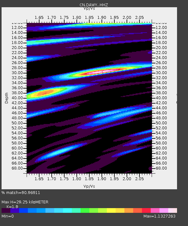
DAWY Dawson, YT, CA - Earthquake Result Viewer
| Earthquake location: |
Mariana Islands |
| Earthquake latitude/longitude: |
15.8/146.9 |
| Earthquake time(UTC): |
2024/04/02 (093) 09:54:09 GMT |
| Earthquake Depth: |
10 km |
| Earthquake Magnitude: |
6.2 mww |
| Earthquake Catalog/Contributor: |
NEIC PDE/us |
|
| Network: |
CN Canadian National Seismograph Network |
| Station: |
DAWY Dawson, YT, CA |
| Lat/Lon: |
64.06 N/139.39 W |
| Elevation: |
771 m |
|
| Distance: |
68.8 deg |
| Az: |
26.925 deg |
| Baz: |
262.421 deg |
| Ray Param: |
0.0560804 |
| Estimated Moho Depth: |
29.25 km |
| Estimated Crust Vp/Vs: |
1.90 |
| Assumed Crust Vp: |
6.566 km/s |
| Estimated Crust Vs: |
3.456 km/s |
| Estimated Crust Poisson's Ratio: |
0.31 |
|
| Radial Match: |
90.96911 % |
| Radial Bump: |
336 |
| Transverse Match: |
61.2582 % |
| Transverse Bump: |
400 |
| SOD ConfigId: |
34025071 |
| Insert Time: |
2024-04-16 10:08:39.634 +0000 |
| GWidth: |
2.5 |
| Max Bumps: |
400 |
| Tol: |
0.001 |
|

Signal To Noise
| Channel | StoN | STA | LTA |
| CN:DAWY: :HHZ:20240402T10:04:41.990027Z | 2.2257547 | 3.320055E-7 | 1.4916537E-7 |
| CN:DAWY: :HHN:20240402T10:04:41.990027Z | 2.4282415 | 1.9594744E-7 | 8.0695195E-8 |
| CN:DAWY: :HHE:20240402T10:04:41.990027Z | 1.1179333 | 1.748965E-7 | 1.5644628E-7 |
| Arrivals |
| Ps | 4.2 SECOND |
| PpPs | 12 SECOND |
| PsPs/PpSs | 17 SECOND |


