You are here: Home > Network List > MB - Montana Regional Seismic Network Stations List
> Station HRY Helena York Bridge > Earthquake Result Viewer
HRY Helena York Bridge - Earthquake Result Viewer
| Earthquake location: |
Mariana Islands |
| Earthquake latitude/longitude: |
15.8/146.9 |
| Earthquake time(UTC): |
2024/04/02 (093) 09:54:09 GMT |
| Earthquake Depth: |
10 km |
| Earthquake Magnitude: |
6.2 mww |
| Earthquake Catalog/Contributor: |
NEIC PDE/us |
|
| Network: |
MB Montana Regional Seismic Network |
| Station: |
HRY Helena York Bridge |
| Lat/Lon: |
46.71 N/111.83 W |
| Elevation: |
1344 m |
|
| Distance: |
86.2 deg |
| Az: |
42.553 deg |
| Baz: |
288.905 deg |
| Ray Param: |
0.044244107 |
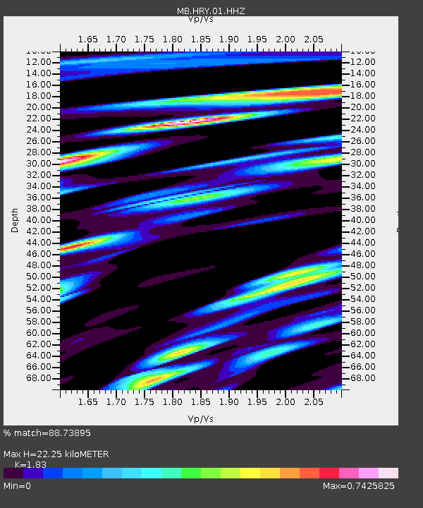
| Estimated Moho Depth: |
22.25 km |
| Estimated Crust Vp/Vs: |
1.83 |
| Assumed Crust Vp: |
6.306 km/s |
| Estimated Crust Vs: |
3.446 km/s |
| Estimated Crust Poisson's Ratio: |
0.29 |
|
| Radial Match: |
88.73895 % |
| Radial Bump: |
400 |
| Transverse Match: |
83.14825 % |
| Transverse Bump: |
400 |
| SOD ConfigId: |
34025071 |
| Insert Time: |
2024-04-16 10:13:34.154 +0000 |
| GWidth: |
2.5 |
| Max Bumps: |
400 |
| Tol: |
0.001 |
|

Signal To Noise
| Channel | StoN | STA | LTA |
| MB:HRY:01:HHZ:20240402T10:06:18.840002Z | 4.16557 | 5.816107E-7 | 1.3962332E-7 |
| MB:HRY:01:HHN:20240402T10:06:18.840002Z | 1.0391132 | 1.5556502E-7 | 1.497094E-7 |
| MB:HRY:01:HHE:20240402T10:06:18.840002Z | 4.020936 | 3.7811225E-7 | 9.403588E-8 |
| Arrivals |
| Ps | 3.0 SECOND |
| PpPs | 9.8 SECOND |
| PsPs/PpSs | 13 SECOND |


