You are here: Home > Network List > MB - Montana Regional Seismic Network Stations List
> Station LRM Limekiln Ridge > Earthquake Result Viewer
LRM Limekiln Ridge - Earthquake Result Viewer
| Earthquake location: |
Mariana Islands |
| Earthquake latitude/longitude: |
15.8/146.9 |
| Earthquake time(UTC): |
2024/04/02 (093) 09:54:09 GMT |
| Earthquake Depth: |
10 km |
| Earthquake Magnitude: |
6.2 mww |
| Earthquake Catalog/Contributor: |
NEIC PDE/us |
|
| Network: |
MB Montana Regional Seismic Network |
| Station: |
LRM Limekiln Ridge |
| Lat/Lon: |
45.82 N/112.45 W |
| Elevation: |
2329 m |
|
| Distance: |
86.1 deg |
| Az: |
43.536 deg |
| Baz: |
288.525 deg |
| Ray Param: |
0.044331487 |
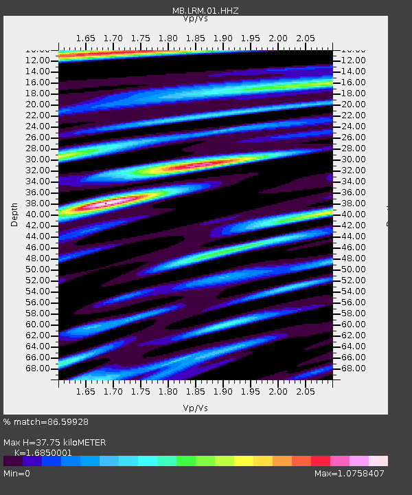
| Estimated Moho Depth: |
37.75 km |
| Estimated Crust Vp/Vs: |
1.69 |
| Assumed Crust Vp: |
6.577 km/s |
| Estimated Crust Vs: |
3.903 km/s |
| Estimated Crust Poisson's Ratio: |
0.23 |
|
| Radial Match: |
86.59928 % |
| Radial Bump: |
400 |
| Transverse Match: |
80.496216 % |
| Transverse Bump: |
400 |
| SOD ConfigId: |
34025071 |
| Insert Time: |
2024-04-16 10:13:36.111 +0000 |
| GWidth: |
2.5 |
| Max Bumps: |
400 |
| Tol: |
0.001 |
|

Signal To Noise
| Channel | StoN | STA | LTA |
| MB:LRM:01:HHZ:20240402T10:06:18.240027Z | 3.4783125 | 5.730531E-7 | 1.6475032E-7 |
| MB:LRM:01:HHN:20240402T10:06:18.240027Z | 0.6758443 | 8.029205E-8 | 1.1880258E-7 |
| MB:LRM:01:HHE:20240402T10:06:18.240027Z | 1.5705731 | 1.6157951E-7 | 1.02879326E-7 |
| Arrivals |
| Ps | 4.0 SECOND |
| PpPs | 15 SECOND |
| PsPs/PpSs | 19 SECOND |


